Dedicated Toronto trail expert John Allemang recommends the best walks just minutes from freeways and subway stations
Walk I
MURAT YUKSELIR/THE GLOBE AND MAIL > SOURCE: GOOGLE MAPS
Who for: Slow-paced amblers, happy families, contemplative romantics
Time: Thirty minutes to … whatever.
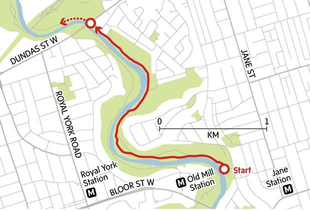
This is easy. Walk the Humber.
Étienne Brûlé Park, just east of Old Mill station, is ideal for an effortless ramble, with the placid river doing most of the work as it flows majestically along beside you. The flood-plain/parkland area is wide open, with picnic areas and places to play for children who find walking a little too earnest a pleasure (but parents need to keep an attentive eye out for hard-charging cyclists).
Ducks, herons and other water birds offer a distraction, and the salmon run in September is a stunning sight for walkers who thought they were just out for a sleepy stroll. The northward path, like the river, goes on and on, so the only challenge may be figuring out when to turn back – ask yourself, "Am I half-tired now?"
Walk II
Murat Yukselir/The Globe and Mail > Source: Google Maps
Who for: Nature lovers, urban escapists, Bridle Path millionaires seeking the true meaning of life
Time: One to two hours
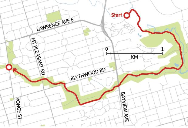
The Glendon Forest trail emerges unpromisingly out of the riverside parking lot of York University's eastern campus and follows the sinuous meanderings of the Don to a point where you suddenly realize the city must have disappeared.
Toronto's showiest mansions are at the top of the hidden hills to the left, university buildings have turned into Sunnybrook's massive mega-hospital well off to your right, and yet the dominant emotions are pastoral and peaceful.
It can't last – somebody is bound to be holding a rousing weekend fundraiser in Sunnybrook Park to the south, but for just long enough, even as you stride forward at an energetic pace, fragrant time stands still. This is where you bring a newcomer to show off the intense Toronto pleasure that ravine walking so readily provides.
You can do an about-face on hitting Sunnybrook, renouncing the more built-up idea of parkland. Or continue south and west to the closed-in, ravine-like Burke Brook, which will take you to Bayview if you cheat a bit (officially, the trail to the road is closed). The Burke Brook trail continues west across Bayview just north of Mount Hope Cemetery.
Here and there, the path is channelled into enclosed, fenced-off wooden walkways designed to restore the degraded ravine area, but the tall trees and flowing brook and constant surprise of being able to navigate huge lengths of off-road Toronto remain a treat.
As civilization begins to reassert itself (tennis courts, a road), the trail peters out just short of Lawrence station at a formal park named after Alexander Muir, who composed The Maple Leaf Forever in 1867. But it's the less formal patches of pedestrianism that make this place of ours eternally memorable.
Walk III

Murat Yukselir/The Globe and Mail > Source: Google Maps
Who for: Determined walkers who enjoy distance, urban explorers unafraid of improvisation, vagabonds and pilgrims who want to zone out for a really long time
Time: Three to four hours
This continuous hike knits together some of central Toronto's best trails, but you can also pick out individual components that are a pleasure in themselves.
It's long been a favourite of mine, partly for its serious length, which reminds me of dreamy vacation hikes up and down the hills of France, partly for its extraordinary variety – an old commuter rail line, an elegant 19th-century cemetery, a rustic ravine that morphs suddenly into a cricket pitch, the deep, dark valley of Moore Park that persuaded my English friend he was in a Group of Seven landscape – but no, this is just one of midtown Toronto's quiet wonders.
Wayfinding at various connection points can be a bit fiddly, so this description is more technical than poetic: Supply your own lyricism. I start at the Heath St. exit of St. Clair West subway station, which leads directly north into Cedarvale Ravine. You can just as easily join the walk from Davisville, St. Clair, Summerhill or Rosedale stations. Cedarvale blends deep ravine-walking with a more open sports-field and dog-park stretch that leads straight north toward Eglinton West subway station.
Here's the first tricky bit: Pick up a pedestrian walkway on the west side of the Allen Road, turn right at the first street and cross the bridge – the flat, shaded Beltline Trail begins a few steps to the north. Except for a few road crossings, and the sudden apparition of the odd manic cyclist, you can breathe easy until you enter Mount Pleasant Cemetery just east of Yonge. Keep to the north road of the cemetery or the grassy, tombstone-edged equivalent, offering respects at the plot of former prime minister Mackenzie King en route, and cross under Mount Pleasant Road before veering southeast toward the cemetery buildings at Moore Ave.
Straight across Moore is a steeply descending path lined by towering trees: Head south on the long, effortless downhill past the Brickworks (bathrooms!), with wide views of the highwayed Don Valley, before darting west onto a riverside trail that takes you through the serene confines of hidden lowland Rosedale. Milkman's Lane climbs the southern hill to Craigleigh Gardens and some awesome bits of real estate, but I keep going west across Mount Pleasant (take care) and into the beautiful, but increasingly degraded David Balfour Park.
You can head north into Mount Pleasant Cemetery and call it quits, if you want. I make my way to the beckoning tower of the Summerhill LCBO via the steep, messy paths on the west hillside and climb one of the staircases on either side of the railway bridge (the southern one is currently out of commission, though you can scramble your way through).
After a bracing sip of wine or beer at one of the LCBO tasting bars (they may be unstaffed – ask for help), head west along Cottingham, through the self-proclaimed Republic of Rathnelly, and pick up the Nordheimer Ravine near the top of Boulton Drive. This nicely varied patch of urban semi-wildness takes you under the Spadina Bridge and back up to St. Clair. To reach Cedarvale, cut through the Loblaws car entrance and St. Michael's College beyond, keeping the natural flow of the lost valley in mind – the ravine magically reappears just north of the synthetic football field.