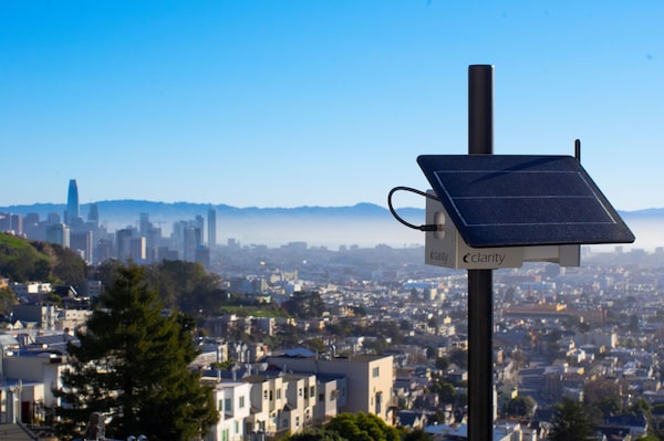
Air quality sensors from companies like Berkeley, Calif.-based Clarity Movement are helping cities collect data and solve difficult problems.Clarity Movement
Jonathan Jay has spent his career finding correlations between unlikely urban phenomena.
Using big data, or large, complex datasets, the researcher and assistant professor at the Boston University School of Public Health has spotted connections between elements such as abandoned buildings, tree cover and gun violence. In a recent study with the Bloomberg Harvard City Leadership Initiative, Jay and his team combined satellite imagery with local police-shooting data in Rochester, N.Y., and found that demolishing abandoned buildings can lead to a 14-per-cent reduction in gun violence rates.
“Big data can very quickly give you a sense of what the patterns are and how they apply in a given location,” Mr. Jay says. “What the algorithm is picking up is the ways in which people have made inequitable decisions about where to invest. And that’s an important driver in gun violence patterns.”
Jay is one of many researchers harnessing big data to answer questions that have long challenged city planners. By collecting millions of data points from sensors, cameras, mobile phones and connected vehicles, urban planners can gain valuable insight into how their citizens live and move, with the aim of making cities smarter, safer and more efficient.
In Berkeley, Calif., for instance, air-quality monitoring company Clarity Movement is developing sensors that can be installed throughout cities and track ambient air pollution, uploading results to the cloud – which provide early warnings of wildfire smoke and inform public health decisions. The city of Pune in India is using big data to inform transit-first planning decisions, including traffic-free corridors for ambulances.
For cities, big data can be used in a seemingly endless number of ways to improve residents’ health and social outcomes. It can also spur economic growth.
Martin Morzynski, senior vice-president of marketing at Streetlight Data – a big data company focused on the transportation sector – says data are helping cities adjust to new realities.
His company has been approached by governments in Houston and San Francisco which are looking to inject economic life back into cities after COVID-19 brought on sudden changes to urban life. This includes modifying transit schedules to meet new, off-peak commuting demands and increasing the presence of bike lanes and sidewalks in areas with reduced vehicle traffic.
Research from PricewaterhouseCoopers and the City of Montreal found that there has been a 10 per cent to 20 per cent drop in commutes to urban cores in Canada’s six biggest cities since the start of the pandemic. Mr. Morzynski says this is forcing governments to rethink city life and how they allocate resources.
“Old [city planning] developed prepandemic may no longer be relevant, because people are moving differently,” he says. For example, Mr. Morzynski notes that fewer commuters downtown means fewer people getting haircuts, buying coffee and using local services – resulting in economic downturns for historically bustling urban centres.
Smart cities of the future may see urban cores focus more on being attractive to residents, rather than commuters and office workers, he says. Data are helping planners adjust. “There is an interest in reviving urban cores in a different way,” Mr. Morzynski says.
Meanwhile, researchers at the Massachusetts Institute of Technology (MIT) are using Twitter location data to track tweets in designated slow zones in Paris, France, helping urban planners measure how effective reducing vehicle traffic is at boosting social activity.
Those slow zones brought more foot traffic to businesses, increasing economic activity – according to Fabio Duarte, one of the researchers involved, and a lecturer of technology and urban planning at MIT’s Senseable City Lab.
Mr. Duarte says there are two main ways cities are collecting big data. The first he calls “specifically designed” data, which includes anything deployed by a city to collect data points. This can include censuses, surveys and physical sensors – such as the ones used by Clarity Movement. The second is what Mr. Duarte calls “opportunistic” data, which are collected from existing sources such as social media, connected cars or smartphone data.
Installation of sensors has traditionally been expensive and often out of reach for areas with low economic output, Mr. Morzynski says.
“Opportunistic data” are cheap and often publicly accessible – though Mr. Duarte says it has its limitations.
For example, using Twitter data, like that used in the slow zones in Paris, limits samples to the site’s users. Cellphone data often exclude marginalized communities who may not have access to connected devices.
“Big data can often be blind to small data,” Mr. Duarte says. “If we miss the small data portion of our society, we might be reinforcing the way society has [traditionally behaved.]”
In some cases, big data can be used to identify economic disparities and find ways to address them, as exemplified in Jonathan Jay’s research on gun violence in Rochester. Mr. Jay and his team have also trained algorithms to identify disinvestment in neighbourhoods using publicly available aerial imagery and Google Streetview data. The model recognizes urban form patterns of low-investment areas, such as high density, low green space, tight row houses and cracked concrete.
Mr. Jay notes that central to harnessing big data is community engagement. “[Even with big data] we don’t have nearly as much information as the people that live in those neighbourhoods,” he concedes. “They draw on their own experiences, priorities and information.”
Another barrier to harnessing opportunistic data is the reliance on platform companies, which have the power to restrict or do away with certain accesses at their discretion. For instance, in 2018, Google restricted the use of its location data for government organizations. In 2021, Apple began requiring user permission for most data-tracking services.
Still, the loss of one dataset often opens the door for another. Streetlight Data’s Mr. Morzynski says the company initially relied on personal GPS data and location-based services data (LBS), but has since shifted focus to connected vehicle and commercial GPS data because of changing privacy laws. In this industry, Mr. Morzynski says, data sources evolve all the time. “Years ago there weren’t enough [electric vehicles] on the road to track, but now we have an electric-vehicle metric,” he says.
He’s quick to assure that Streetlight isn’t in the business of tracking people, but rather measuring how transportation moves at scale. “What matters when you manage transportation is not that an individual walks from their home and completes the trip by bike. It matters what the larger group is doing.”
Mr. Jay hopes the use of big data in urban planning drives more applied research that has deep roots in community partnerships. “I hope that cities feel like they can look outside the box in terms of the types of data they can use,” he says. “And the questions they can answer.”