
Along the Beaufort Sea in Tuktoyaktuk, NWT, homeowners face tough decisions about whether to relocate farther inland or stand their ground against increasingly destructive natural forces: Rising sea levels, erosion and thawing permafrost.Patrick Dell/The Globe and Mail
Graphics by Murat Yükselir
Sandy and Sarah Adam reside at 123 Beaufort Dr. on the northernmost peninsula in Tuktoyaktuk, NWT. They have spent their entire lives in the remote community, and moved into this one-storey house in 1994. They would like to relocate it across the road, or at least turn it sideways – anything to buy more time in the place they call home. “It’s my ancestors’ land, they used to stay here,” Mrs. Adam said. “It’s special, sacred land.”
But Mr. Adam, sitting on his porch, acknowledged his family is one bad storm away from losing everything. The sea has whittled his backyard, which he estimates once stretched many tens of metres westward, to just two metres. During storms, the Beaufort Sea splashes his house and washes around its foundation of piles. “Every year, it has moved closer and closer,” Mr. Adam said.
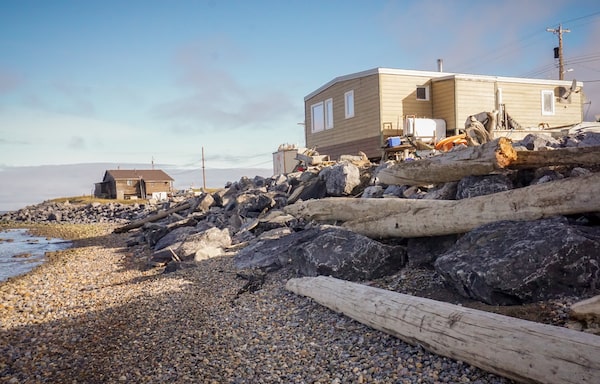
A barrier of boulders, known as rip-rap, buttresses the shore beneath the Adams' home.Matthew McClearn/The Globe and Mail
Just down the road, a sea of white and orange-brown crosses bear the names of deceased Grubens, Nasogaluaks, Capot-Blancs, Steens and Kowanas, framed by an archway inscribed with a request for divine intervention to provide them eternal rest. The Beaufort seems unlikely to honour that request: It has already claimed other graves and historical sites along the fragile coast.

The graveyard in Tuktoyaktuk, near the Adams' home.Patrick Dell/The Globe and Mail
Erosion has been a problem since people first settled here; increasingly violent storms, thawing permafrost and rising sea levels are quickening the pace. A ribbon of boulders (known as rip-rap) along the shore a couple of metres below the cemetery and the Adams’ home are just the latest salvos in a running battle with the Beaufort Sea for the hamlet the locals call Tuk. Those defences have slowed, but not halted the sea’s inexorable advance.
Stand your ground if you can, give way if you must. It is a precept embedded in Inuit culture, and not infrequently a practical necessity of northern living. A review of satellite imagery shows more than half a dozen structures have been removed from the peninsula since the summer of 2016. Hamlet administrators say some homes were moved to Inuvik, while others now sit on vacant lots in Tuk, awaiting future use. Among the last holdouts, Mr. Adam secured relocation funding from the hamlet, found a new lot farther inland and plans to consult a carpenter to see whether his house can withstand relocation.
SEA CHANGE: ABOUT THE SERIES
The world’s oceans have been rising in lockstep with global temperatures since the mid-1800s – and the pace is accelerating. In this five-part series, Sea Change, The Globe and Mail examines how Canada’s most vulnerable coastal communities are preparing for an inexorable force that will reshape their coastlines – in potentially catastrophic ways – for generations to come.

Coastal sensitivity
to climate change
Low
Medium
High
Tuktoyaktuk
0
2
KM
NORTHWEST
TERRITORIES
MURAT YUKSELIR / THE GLOBE AND MAIL,
SOURCE: CANCOAST

Coastal sensitivity
to climate change
Low
Medium
High
Tuktoyaktuk
NORTHWEST
TERRITORIES
0
2
KM
MURAT YUKSELIR / THE GLOBE AND MAIL,
SOURCE: CANCOAST

Coastal sensitivity
to climate change
Low
Medium
High
Tuktoyaktuk
NORTHWEST
TERRITORIES
0
2
KM
MURAT YUKSELIR / THE GLOBE AND MAIL, SOURCE: CANCOAST
PART 4: TUKTOYAKTUK, NWT
Population: 898
Projected sea-level rise by 2100: 42 to 68 cm
WHAT THE SCIENCE SAYS
Read Matthew McClearn's primer on the science behind this series.
A Sisyphean task
Talk of the worst-case scenario – abandoning Tuk entirely – goes back at least a generation. “Attempts to control erosion at Tuktoyaktuk will become increasingly expensive and the site could ultimately become uninhabitable,” predicted a 1998 paper by the Geological Survey of Canada. The hamlet is trying to draw up a formal plan to avoid that fate. But time is running out.
The Beaufort coastline is exceedingly challenging to defend. Comprised largely of soft sediments, it has been retreating for thousands of years: By one Geological Survey of Canada estimate, about 7,000 years ago it lay more than 100 kilometres north of its current position. Tuk’s harbour is actually a flooded river valley. “There’s no bedrock anywhere there,” said Donald Forbes, a retired research scientist whose career with the Geological Survey of Canada brought him to Tuktoyaktuk numerous times beginning in the 1970s.
Back in the 1930s, the Hudson’s Bay Co. was looking for a Beaufort Sea port to transfer freight brought down the Mackenzie River by barge to deeper-draught coastal vessels. It selected one of the Beaufort’s only viable harbours, east of the Mackenzie delta, and dubbed it Port Brabant. (In 1950, it became Tuktoyaktuk, the first community in Canada to revert to a traditional Indigenous name.) The surrounding landscape is dominated by pingos − towering mounds of earth pushed skyward by ice underneath − which form only in permafrost environments.
The community’s geological vulnerability was obvious from the outset: Within a decade, HBC had lost buildings to flooding, and its employees had already observed serious erosion. By the time Tuk was incorporated as a hamlet in the 1970s, the town’s coastline had retreated as much as 100 metres inland in places; the elementary school and curling rink were in jeopardy. But Tuk was emerging as the key staging area for oil and gas exploration across the Beaufort Sea. It still has some political significance as one of Canada’s northernmost inhabited settlements, bolstering Canada’s claims to its northern regions.
So began the battle. A series of “Longard” tubes − sausage-shaped cylinders filled with sand – were installed in 1976 on the shore in front of the school to slow the erosion. These were destroyed, although the cause remains disputed. (A 1982 study by the federal Public Works department blamed vandalism; others pointed to driftwood and sea ice.) The school had to be abandoned, and the curling rink succumbed to the sea during a 1982 storm.
In the late 1980s, the hamlet added dredged sand to its beaches, and shored them up with sandbags. Storms undermined and broke the lower bags, spilling their contents and causing those above to collapse. Concrete footings salvaged from the school were placed on the shore, but they, too, were undermined by the elements and toppled. A single storm in 1993 destroyed half the shoreline defences.
In 1998, an oil company donated 40 concrete slabs, which were installed on gravel pads along 100 metres of shore at the peninsula’s north end. The Geological Survey of Canada has monitored all of the community’s coastal defences for years; Dustin Whalen, a physical scientist, said the slabs, which direct the waves upward and away from the shore, have performed well.
But concrete pads simply are not an option to protect the rest of the community. “It’s very costly to fabricate them here or bring them in,” said Darrel Nasogaluak, who served as mayor last year. “And to locate them properly, you need a big heavy-lift crane, which we don’t have anywhere in the North right now.”
So during the past 20 years, the community installed rip-rap brought in from Inuvik along the peninsula. A review of historical satellite imagery by The Globe suggests this significantly slowed erosion. Yet it is also a Sisyphean task. The boulders are porous: water infiltrates and freezes, splitting them into ever-smaller fragments. The shore is littered with scraps of geotextile fabric torn from underneath the rip-rap by waves, bunched up and useless.

These concrete slabs have been one of the more effective remedies for Tuktoyaktuk's erosion problems, but installing more of them is prohibitively difficult and expensive.Matthew McClearn/The Globe and Mail
A foundation of ice
One reason shoreline defences proved so ineffective is that Tuk essentially rests on a foundation of ice. The Arctic is warming at twice the global average; temperatures across the Northwest Territories increased by three to four degrees in just half a century. “As air and sea temperatures rise, that promotes more rapid recession through melting of excess ground ice and thawing of ice-bonded sediments,” Mr. Forbes explained. Unlike eroding soils, melting ice does not even contribute materials toward a beach that might buffer against future erosion. It just melts.
Tuktoyaktuk’s thawing beaches offer a pitiful foundation for coastal defences. “There were rocks all the way down past my house,” resident Noella Cockney, a retired RCMP officer who lives on the peninsula, said from the cab of her pickup truck. “But because of the force of the waves and the moisture, everything sunk into the beach.”
Tuk used to be sheathed in sea ice from October to June. The warming climate shortened that season, extending the period during which Tuktoyaktuk is exposed to the storms that blow in predominantly from the north and the west.
For these reasons, the Beaufort Sea would eventually claim Tuk even if it weren’t rising. But it is rising. And the Earth’s crust is also subsiding underneath. The combined result of both forces is stark: The Geological Survey of Canada predicts that if human carbon emissions continue unabated, sea level along the Beaufort coast will rise about 70 centimetres between now and 2100.
Tuktoyaktuk flooding scenarios
SOURCE: GEOLOGICAL SURVEY OF CANADA
Even this conservative estimate, if realized, would greatly increase flood risks. Flood maps show that if the Beaufort rose just one metre, about 14 per cent of the community would be flooded. At two metres, more than one-third of Tuk goes underwater. Get to three metres, and nearly three-quarters of the hamlet floods. Any combination of sea level rise, storm surge and wave action could deliver such levels.
Tuktoyaktuk is running low on options. With its oil and gas heyday a distant memory, it is all the more difficult to attract funding from the territorial and federal governments to support expensive new infrastructure projects to mitigate erosion and flooding.
The opening of a permanent, all-weather road last year that connects Tuk to Inuvik does open new possibilities: It should reduce the cost of bringing in boulders and other materials, for example. And there is hope the road will bring in flocks of tourists to rejuvenate the economy. But it will not alter the fundamental shortcomings of traditional shoreline-protection measures.
“There’s been no real concentrated effort in the last decade” to halt erosion in Tuk, said Lorie Fyfe, a regional superintendent of Municipal and Community Affairs for the territorial government, who visits the community two or three times a year. The community is instead pursuing an informal strategy of gradual retreat to inland locations such as a new neighborhood called Reindeer Point.
Mr. Nasogaluak explained that the peninsula, which is the site of the northern terminus of the Great Trail (formerly the Trans Canada Trail), has been designated an “environmental reserve,” and will be for day-use only. “We can’t protect it long-term,” he said. The hamlet will continue to replenish the rip-rap in front of its cemetery, Mr. Nasogaluak said, but elsewhere the defences will be discontinued. The community will slowly move inland, he predicted.
Tuktoyaktuk coastal erosion
SOURCE: GEOLOGICAL SURVEY OF CANADA; BING MAPS
But there are likely limits to how far the community can retreat inland and remain economically viable. Although the Hudson’s Bay Company is a distant memory, Tuk’s habour remains its raison d’être. So far, the harbour has been spared from the erosion that has destroyed so much of the peninsula, thanks to Tuktoyaktuk Island. It’s one of many barrier islands across the Arctic − long, sandy formations that shelter the nearby coast. Tuk Island guards the harbour from storm surges and wave action, and probably also prevents it from silting up.
But the same forces that ruined the peninsula are destroying the island. Its northern coast retreats at about two metres a year, Mr. Whalen said. Digitized historical coastlines produced by the Geological Survey of Canada using aerial and satellite photos show it retreated around 130 metres between 1947 and 2008. Much of the eroded material has been deposited in the main shipping channel, and Mr. Whalen predicts the island will be breached in 2037. Separated into several smaller islands, it might erode even more quickly. Once Tuk Island breaks up, the harbour will be exposed to “much bigger waves than ever before,” he warned.
Tuktoyaktuk Island coastal erosion
SOURCE: GEOLOGICAL SURVEY OF CANADA; BING MAPS
Rusting relics
On the island’s northeast shore lies the remains of an old wooden barge, which may suggest a solution. It has laid there rotting for Mr. Nasogaluak’s entire life. As a child, he hunted ptarmigan (a game bird in the grouse family) on the island’s dunes and bluffs with a slingshot. “That old barge is almost beat to nothing now, but it protected that island,” Mr. Nasogaluak said. “That is the only spot on Tuk Island that hasn’t seen any erosion.”
Some old steel barges recently became available after the bankruptcy of a northern company, Mr. Nasogaluak said. The community considered sinking them off Tuk Island to form an offshore breakwater. “We’re not sure if we want to put some rusting relics out there,” he said. “But, I mean, it may be the only way.”

Darrel Nasogaluak served as mayor of Tuktoyaktuk last year.Patrick Dell/The Globe and Mail
Mr. Whalen believes putting some kind of barrier in front of Tuk Island is “inevitable.” This year, he hopes to study how much the seabed would sink if a heavy barrier were placed on it − information he thinks the hamlet will need one day soon.
Last year, the territorial government helped Tuktoyaktuk secure $250,000 in federal funding to hire a coastal engineer to prepare a flood and erosion mitigation plan. Part of its argument was that Tuk’s harbour must be preserved to support future oil and gas exploration and production in the Beaufort Sea. Administrators hope the plan will help the hamlet secure much larger sums of federal funding to execute the plan. But it could be difficult to find a consultant whose experience exceeds that of local leaders. “The real issue is that there isn’t really engineering expertise to manage erosion of an ice-rich shoreline in a setting like that,” Mr. Forbes said.
Even if the hamlet can stabilize its own shores, residents can do little else but watch the continuing disintegration of the rest of the Beaufort coast.
Climate change is also threatening the Inuit way of life, says the head of the Inuvialuit Regional Corporation, which manages more than 90,000 square kilometres of land granted to the Inuit of this region through a treaty with the federal government in 1984.
Duane Ningaqsiq Smith, the IRC’s chair and CEO, said Tuk residents depend on hunting and fishing over a huge area to supplement their diets. Mr. Smith has had to replace his own hunting cabin twice in recent years because of damage from storms that he said are becoming increasingly violent. “A lot of the other areas along the Western Arctic coastline of Canada are eroding away,” he added. “It’s significantly increased within the last five years.”
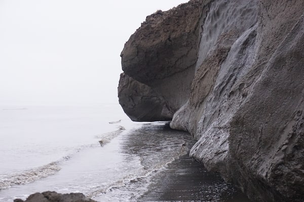
On Baillie Island, northeast of Tuktoyaktuk, cliffs once held together by permafrost are undercut by waves on a warming and rising ocean, causing massive blocks of earth to topple into the sea.Matthew McClearn/The Globe and Mail
‘We’re coastal people’
The implications became clear during last summer’s Canada C3 expedition, when participants visited Baillie Island, about 225 kilometres northeast of Tuk on the Beaufort Coast. There, massive blocks from the island’s cliffs slough off into the sea, bowing into the surf like penitent monks. On a smaller but accessible block that had recently fallen, the melting permafrost that had until recently bonded the cliff together could be seen. In places, people’s boots sank several inches into the quicksand-like beach.
But even that pales in comparison to Pelly Island, 100 kilometres west of Tuk. Every year, members of the Geological Survey of Canada visit Tuktoyaktuk to monitor the deterioration of the surrounding coastline. At as much as 40 metres a year, Pelly Island’s coastal retreat rate is among the most rapid witnessed anywhere on Earth.
Their options limited by geology, remoteness and financial resources, Tuk’s residents must live with their deteriorating coastline. But Mr. Nasogaluak suggested the region’s Inuit are undaunted by change. “My grandfather was born in an igloo,” he said. “My mother was born in a tent. And I was born in a tent in a government community. We’re an adaptive people; we’ve been through a lot in the last 100 years.”
A 2014 hazard-risk assessment published by the territorial government made a similar point: People who live in isolated communities such as Tuk are accustomed to violent weather, power and communications failures, and their traditional knowledge of local conditions leaves them better prepared for natural disasters.
“We’ll always be on the shoreline, whether it’s where it is today, or wherever the shoreline’s going to be in 100 years,” Mr. Nasogaluak said. “We’re coastal people.”

Tuktoyaktuk's residents can do little but watch their coastline deteriorate, but Mr. Nasogaluak says the region's Inuit will persevere. 'We’re an adaptive people.'Patrick Dell/The Globe and Mail