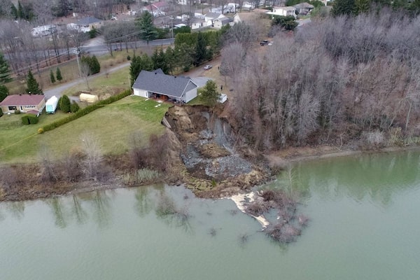
Dominique Feuiltault’s house in Saint Roch de Richelieu, Que., hangs on the edge of a cliff after a landslide last fall. Tonnes of earth went slumping into the Richelieu River while he and his wife were sleeping.
Every time Dominique Feuiltault looks at the void at the edge of his house, he considers the many ways the landslide could have been worse.
The sudden slump of tonnes of land last fall could have carried his home into the Richelieu River in the middle of the night when he and his wife were sleeping. “Every time I look at that cliff, I think about how if I had cut the grass that day, I’d have been in the river under the mud with my cedars,” Mr. Feuiltault said.
Mr. Feuiltault instead finds himself in bureaucratic muck with dozens of other Quebec landslide victims, arranging for the salvage of his home while quarrelling with the province’s natural disaster compensation program over every expense to move his teetering house to safer ground. It’s very trying, the part-time firefighter and industrial designer says, but “don’t get me wrong. I’ve seen a lot of bad things happen and I know at the end of the day we’ll sort it out.”
After a disastrous flood season in Quebec last year damaged or destroyed thousands of homes, landslides have caused hundreds of smaller disasters that are highly localized, but also less predictable and potentially more deadly than the rising waters. Quebec received 350 reports of landslides in 2017 that caused property damage, nearly triple the recent average. Homes have been destroyed, a hydro tower was damaged and a major freeway closed for more than a month after ground gave away.
In British Columbia, 75-year-old Roy Sharp of Tappen died when he was swept away by mud in May. In 2017, highways were repeatedly closed and dozens of people were evacuated due to landslides.
Canada is one of the safest countries in the world, where millions are invested each year to predict and prevent the better-known dangers of floods, forest fires and the weather. But landslides are a peril that gains little notice. They kill people, cause hundreds of millions of dollars in damage and economic loss each year, but remain nearly as vexing as earthquakes and lightning strikes to predict. Satellite monitoring for warning signs is in its infancy and prohibitively expensive.

A deadly history
Landslides have killed more Canadians than floods, hurricanes and tornadoes since 1900, according to the Canadian Disaster Database kept by Public Safety Canada. At least 654 Canadians have died in landslides going back to the 18th century, according to Natural Resources Canada, and landslides cause $200-million to $400-million in damage annually. The only deadlier natural phenomena in Canada have been winter and summer storms, mainly because of the hundreds of people killed off the coasts and on the Great Lakes during maritime disasters in the first half of the 1900s.
The spike in landslides in Quebec can be linked directly to the record spring rains that triggered the floods and saturated ground, according to Denis Demers, the engineer-geologist in charge of land movement at Quebec’s Ministry of Transport. “We had some of the biggest rains we’ve ever seen,” he said. “With such phenomenal quantities of water, we have slopes that will slide prematurely.”
While the word “landslide” evokes in image of boulders and mud roaring down steep mountains, a large portion of slides occur in slumping clay left behind by glaciers and an inland sea in the St. Lawrence, Ottawa and Saguenay River valleys. The clay has various names, including Quick, Leda and Champlain Sea clay, but has one killer trait: It turns into liquid under enough stress, either by natural or man-made forces.
The historical record shows at least 278 people have died in landslides in British Columbia and 233 in Quebec. The deadliest single slide occurred in Frank, Alta., in 1903, in which at least 73 people died. While 93 of the Quebec deaths occurred in four separate rock slides in the 1800s on Champlain Street in Quebec City, the rest have come along river and creek valleys where unpredictable glacial-marine clay has suddenly given way.
Every few years, entire families are wiped out when landslides strike a home, such as the 2010 slump that buried a family of four in Saint-Jude, Que., or in 2012, when four people died in Johnsons Landing, B.C. More rarely, entire neighbourhoods disappear. In 1971, a slide in Saint-Jean-de-Vianney, Que., killed 31 people. Ten years later, the M Creek slide in British Columbia wiped out a bridge and sent nine motorists into a canyon.
Canadians can also look south right for the damage landslides can do: 21 people died in January in California landslides provoked by rain that followed wildfires.
Landslide deaths in Canada remain mercifully rare compared to other perils like car accidents, Mr. Demers pointed out, “but they are a huge inconvenience for people and cost a fortune in property damage.”

Alberta, 1903: A miner’s cottage is buried in rubble after 82 million tonnes of rock came pouring down Turtle Mountain, devastating the small coal-mining town of Frank. At least 73 people were killed in what would come to be known as the Frank Slide, Canada’s deadliest landslide.FRANK SLIDE INTERPRETIVE CENTRE/AFP/Getty Images
Predicting the unpredictable
While weather forecasting and navigation improved vastly to reduce nautical fatalities associated with storms, landslide prediction is still in its infancy, according to John Clague, the chair of natural hazard research in the Earth Sciences department at Simon Fraser University.
Norway has started a landslide detection program using satellite imagery to detect small land movements that can predict landslides, Dr. Clague said. In B.C., only a few areas that are especially landslide-prone are monitored.
“There are new tools coming on board but we haven’t really refined them enough to use them as a predictive tool. It will be some day down the road that we can do that,” Dr. Clague said. “But most landslides do not give you much warning.”
In Quebec, Mr. Demers said the province has made progress over 30 years mapping areas susceptible to slides, based on geographical features such as slope and proximity to water. It’s up to hundreds of municipalities and regional councils to control where people build and up to landowners to avoid bad practices – such as cutting down trees and disturbing the soil – that lead to about 40 per cent of slides.
“We know quite well where slides can happen, but it’s impossible to predict when,” Mr. Demers said.
The mapping is an imperfect tool, however. The site of the 2010 Saint-Jude slide was listed as low-risk. “There are still fine details in the geology that make areas prone to failure that we don’t really understand yet,” Dr. Clague said. “There are ways of making preliminary estimates of hazard, but at the end of the day they still are unpredictable. It makes land-use planning very tough.”
Even when municipalities know their high-risk zones, management is complicated. “A lot of these properties were bought and developed long before we had a proper understanding of what was happening,” Dr. Clague said. “You can’t really work retroactively. You have to work from the present. But even at that, these events are rare enough that people are prepared to take certain risks.”
The good news, according to Mr. Demers, is that a year with a lot of landslides in Quebec’s clay soils is usually followed by more stable years. “It’s like when you shake an apple tree. A lot of the apples ready to fall will go, but afterward you will wait a while for more to come down,” he said. “We anticipate a better year next year.”
 Les Perreaux