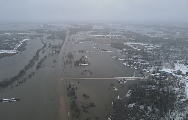
Flooding on the Peguis First Nation, in Manitoba, on May 1.Albert Stevenson/The Canadian Press
Albert Stevenson was among members of Peguis First Nation who stayed behind Monday after others fled to escape flooding.
“Right now, we’re just checking sump pumps and pump the water out of the yards if we can,” he said by phone from the community about 150 kilometres north of Winnipeg.
A combination of heavy rain on the weekend and ice jams on the Fisher River raised water levels, which prompted the evacuation of some 200 homes close to the river that house more than 900 people.
Mr. Stevenson’s parents were among those sent to Winnipeg, but he chose to stay behind with his wife and daughter to try to protect their homes. His house is on higher ground and had not been affected.
“Waters have gone down a bit, but we’re not out of the woods yet.”
The provincial government said later Monday that the river had peaked, although ice jams remained a risk.
The community’s chief, Glenn Hudson, said hundreds of homes were surrounded by water and roads were getting submerged.
“We have been seeing waters at unprecedented levels as far as the Fisher River watershed is concerned,” said Mr. Hudson, who added that water appeared to be higher than during the community’s last major flood evacuation in 2011.
The chief and council of the neighbouring community of Fisher River Cree Nation said some high-risk residents were sent to other areas as the waters rose.
Russell Murdock, whose home is about eight metres from the river, said the Fisher River emergency response team set up a Tiger Dam – stacked, long tubes containing water – around his home two days ago.
“It’s just not doing a job right now. It’s been fruitless, but the guys did what they could,” Mr. Murdock said.
“So far, we’ve managed to keep the water to a certain level underneath the crawl space. Other than that, we’re coping.”
While Manitoba often faces some threat of flooding in the spring, this year has been far worse than normal. Heavy snowfall over the winter, combined with three spring storms in as many weeks, has resulted in saturated land and rising rivers.
Much of Southern Manitoba received four to six times the normal amount of precipitation in April, the provincial government said.
Peguis First Nation has dealt with several floods in recent decades. The community was relocated in 1907 – from good farming land close to Winnipeg to its current location on a flood-prone river delta – under a surrender of land to the federal government that was later deemed illegal.
In some other areas Monday, water rose to cover rural roads, which required people to leave before losing road access.
“There’s about 24, 25 sites that will, at this present time, lose road access,” said Ralph Groening, reeve of the Rural Municipality of Morris, about 50 kilometres south of Winnipeg.
The Red River Valley, which includes Winnipeg, Morris and other areas, is largely protected by community dikes and diversion channels that were expanded after the so-called flood of the century in 1997.
Communities and homes in the valley are protected to a water level of 60 centimetres or more above the 1997 peak.
“Other than what might be some inconvenience and [road] closures, I would suggest we’re confident that our community property is protected,” Mr. Groening said.
The forecast promised some welcome relief. Dry, warm weather was predicted for most of Manitoba for the remainder of the week.
Our Morning Update and Evening Update newsletters are written by Globe editors, giving you a concise summary of the day’s most important headlines. Sign up today.