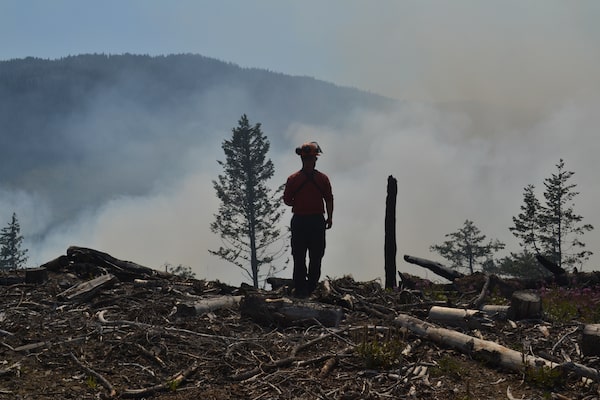
Fire-behaviour specialist Eric Kopetski observes how a fire set by fire crews burns, as part of an effort to combat the Keremeos Creek Fire, on Aug. 17.Anthony Davis/The Globe and Mail
On a sweltering August day, as heat warnings were issued for the Southern Okanagan Valley and regions nearby, Eric Kopetski tramped carefully among smoking stumps and small flames flickering up from the tangled slash of a cut block.
Mr. Kopetski, 40, a fire behaviour specialist with the BC Wildfire Service, was high up in the craggy, forested Cascade mountains, where tentacles of smoke from the north flank of the tenacious Keremeos Creek fire could be seen creeping up various slopes. Reclassified as held on Aug. 26 – meaning the fire was no longer likely to spread further under current conditions and forecasts – it had been the largest out-of-control blaze in British Columbia this year. Located about 20 kilometres southwest of Penticton, it had, by Sept. 1, consumed more than 7,000 hectares of forests and ranchlands.
It was Mr. Kopetski’s eighth day of a 14-day shift on the fire. Each day his job was to gather data on such things as “fuel loads” (the type and dryness of trees and other vegetation in the potential paths of the fire), and to gather hourly measurements on temperature, relative humidity, dew point, wind direction and speed and other indicators from instruments staged around the fire’s perimeter. Then, returning back to the large BCWS base camp temporarily set up at the Oliver Municipal Airport, he fed all that fresh data into Prometheus, a “deterministic” fire-growth simulation model.
Mr. Kopetski, 40, based with Kamloops Fire Centre, is one of 13 fire-behaviour specialists currently with the BCWS. The information they were gathering up in the mountains would be used, with the help of Prometheus, to predict where the Keremeos Creek fire was likely headed in the next day or two.
Fire-behaviour specialists in B.C. and other provinces help their incident commanders make critical decisions about where to put resources on a fire, and where and what preventative measures firefighting crews should take to best battle a wildfire. Those might include, among other things, where to build fire guards or set controlled burns in the anticipated path of a fire in order to starve it of fuel.
There’s no time to dither with such decisions, especially when a fire is first detected, says Mike Flannigan, a leading expert on wildfire behaviour. He was recently appointed British Columbia research chair in predictive Services, emergency management and fire science at Thompson Rivers University. In that role he’s also working with BCWS to improve their predictive abilities as wildfires rapidly grow more extreme with climate change.
The minute a wildfire is discovered, Mr. Flannigan says, “You have to make an appropriate decision whether to fight a fire or monitor it. And that decision has to be made within five minutes. The reason for that is that under extreme conditions your window to deal with a fire can be as little as 15 to 20 minutes. Like the Lytton fire last year – within 20 minutes that was not controllable.”
In his job, Mr. Kopetski favours the Prometheus program, widely used in other Canadian provinces as well. Crunching his daily data collected from around the Keremeos Creek fire, Prometheus generates an interactive map that projects where the fires are most likely to spread in the next one, two, or three days. (Beyond that, the accuracy of weather forecasts critical to Prometheus’s calculations begins to trail off.)
Fire-incident commanders, explains Mr. Kopetski, can use Prometheus to set “trigger points” used to predetermine when to issue evacuation orders, when to move crews around from different parts of the fire, in anticipation of wind shifts, or call in additional resources such as more firefighters or aircraft.
A resident of Williams Lake, B.C., Mr. Kopetski has been with the BCWS for 17 years, starting off as university student fighting forest fires during his summer school breaks. Now he surveyed the land surrounding the Keremeos Creek fire.
In a little settlement called Olalla, where many houses and ranches are tucked in thickets of trees at the valley bottom, rusty coloured scorch marks in the conifers revealed how close the blaze came. If not largely for the work of BCWS firefighters and aircraft, dozens of properties would likely have been torched.
Near Olalla, Mr. Kopetski drove up a steep, winding, forest service road for another 12 kilometres until he reached the smouldering cut block, where logging had left a large patch of stumps and debris in the forest, known as slash. Dressed in the fire-resistant Nomex shirt and pants that clothe BCWS crews, Mr. Kopetski eyeballed the charred plants and wood debris as he scouted the area, located at 1,900 metres elevation in a bowl between rounded mountain tops. Earlier that morning, BCWS helicopters had set fire to the lower part of the bowl as part of an effort to starve the approaching wildfire, which normally would flame up on a feast of Douglas firs and lodge pole pines as it climbed uphill.
Mr. Kopetski needed to see how the crew-set fire was burning.
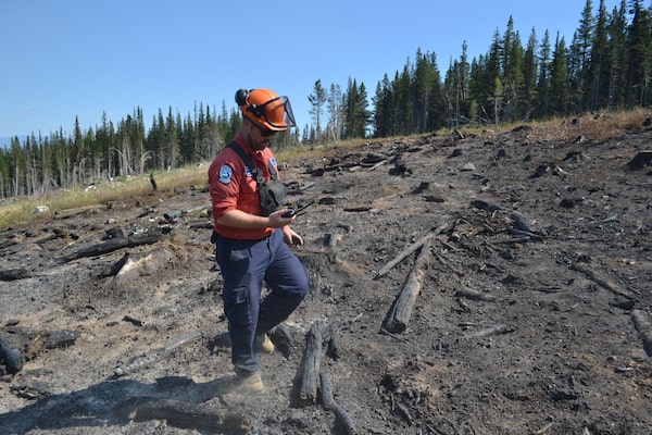
Mr. Kopetski examines how a crew-set fire burned, at 1,900 metres elevation, on the north flank of the Keremeos Creek Fire.
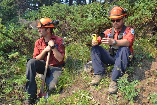
Mr. Kopetski and fellow BCWS firefighter Iain Berglund observe the crew-set fire.Anthony Davis/The Globe and Mail
The Keremeos Creek fire had been a conundrum for firefighters and wildfire managers. Discovered July 29, it had quickly raged lower down in the Similkameen Valley. In dry conditions, a forest fire often quickly spreads up slopes. But, atypically, this one hadn’t, at least not yet. “It’s been kind of hung up as it tries to climb the slopes,” Mr. Kopetski said.
“I would say, with this fire, that what we’ve all been scratching our heads about is, we had a cool, relatively wet spring. Which delayed the snow melt at higher elevations,” Mr. Kopetski says. “I guess the puzzle is if, or when, higher-elevation fuels will become available to the fire?”
In Greek mythology, Prometheus was a god who stole fire from heaven, giving it to mankind. The name is also said to mean “foresight.” First released in 2002, the program Prometheus – specially designed for the Canadian land mass – looks back in time in order to help firefighters look ahead. It’s built upon decades of scientific research aimed at deciphering the physics of fires. But also underlying its computations are decades of Canadian historical weather records, topographical data, including the slope aspects in hilly or mountainous territory, information on the tree and plant composition of forests and plains around the country, and wildfire statistics dating from the 1970s through the 1990s.
Using that data as a foundation, along with complex algorithms built in from the Canadian Forest Fire Behavior Prediction System, Prometheus relies on highly focused weather forecasts throughout the day and data gathered continually on current wildfires of concern to generate the interactive maps illustrating where the flames will likely burn in the following days.
Each day, on 12-hour shifts that sometimes stretch to 16, Mr. Kopetski spends about half his time in the field, the rest at his computer. Driving the dusty forest road around the perimeter of the bowl, Mr. Kopetski stopped here and there to check a series of small Kestrel weather meters set up on tripods or hung in trees. As he stepped closer to the mini weather stations, they pumped information, via Bluetooth, into his cellphone about the last batch of hourly readings of temperature, wind speed and direction, relative humidity, dew point and barometric pressure at each location.
It’s not just the data and algorithms Mr. Kopetski uses with Prometheus that inform the weighty decisions the incident commander on the Keremeos fire, Hugh Murdoch, must make each day on how best to use the crews at his disposal. The BCWS also taps local knowledge of an area as it attempts to prognosticate a wildfire’s behaviour. “We’ve been speaking with representatives of the ranching community and with First Nations,” Kopetski says. ”That’s been helpful in understanding how snow melt typically happens at higher elevations in this area.”
Mr. Murdoch, who has been in the firefighting business 30 years, describes predicting wildfire behaviour as both “a science and an art.” The art of it is the culmination of his own gut instincts along with those of his most experienced wildfire crews. He says that while the science behind Prometheus and similar models has improved with time, so have the complexities of wildfires.
“There’s more infrastructure on the ground, there’s more rural sprawl, there are more cell towers,” he says.
One factor that is not yet inputted into any fire-growth models, he says, is how successful continuing suppression efforts are. “Then it’s worth recognizing that the quality of the weather data that feeds these models is hugely impactful. A variation of a couple of degrees temperature or a couple of points of relative humidity or wind direction” – or even a small error in how grass in a fire zone is curing – can adversely impact predictive accuracy.
The realities of climate change, which makes fire behaviour more extreme, also means some of the data underpinning Prometheus, such as historical weather statistics, is getting dated.
Neal McLoughlin is superintendent of the newly formed predictive services unit for BC’s Provincial Wildfire Coordination Centre. Twenty years ago, he says, most wildfires were “diurnal,” meaning they were most active during the day, especially in the “witching hour” around 5 p.m. Now there’s evidence B.C. fires are becoming increasingly active at night.
“In the 2021 season, which set records,” he says, “a lot of the time fire runs grew at night.”
Mr. McLoughlin is currently involved with a national team that has been working the past five years to make predictive fire-growth models such as Prometheus more automated, spitting out predictions more quickly and accurately. (It should be ready for next year’s fire season.) However, he adds, while work is also going on at the Canadian Forest Service to fine-tune the Canadian Forest Fire Behavior Prediction System and the fire-weather index system that are both components of Prometheus, Canadian climate change data is not being incorporated at this point.
Nor is artificial intelligence and machine learning, which Mr. McLoughlin estimates are five to 10 years away from being incorporated into models such as Prometheus.
Meantime, back up near the cut block, Mr. Kopetski has been gathering a different kind of intelligence, chatting with fellow firefighters about the fire behaviour they’ve seen that day. The Keremeos Creek fire has been burning in rugged, ankle-breaking terrain that has been difficult for BCWS crews to get close to on foot, or even with water-bombers – though helicopters have been used widely. “What we’ve been talking about a lot on this fire is, can we leave portions of it just to sort of burn on its own?” Or, he adds, “Can we use ignition to bring the fire up to a spot where we can actually work it?”
Tapping into the experience of fellow firefighters, the local knowledge of ranchers and First Nations people, and the data he’s been out collecting and feeding into Prometheus daily, he’ll help answer those questions.
We have a weekly Western Canada newsletter written by our B.C. and Alberta bureau chiefs, providing a comprehensive package of the news you need to know about the region and its place in the issues facing Canada. Sign up today.