/cloudfront-us-east-1.images.arcpublishing.com/tgam/ZXG37QYGYZHFLJZUWJ5AIVJUPY.jpg)
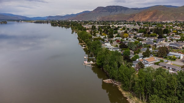
The South Vancouver sea dike runs along a stretch of the north arm of the Fraser River to protect – notionally, at least – Vancouver’s Southlands neighbourhood, an improbable pocket of countryside in the middle of a metropolis of 2.5 million people. Well groomed horses clop down narrow lanes between large, gated estates and riding paths. Expansive golf courses bookend private paddocks, mature trees and expansive emerald lawns.
A little more than 300 buildings, most of them residential, worth a combined value of about $1.7-billion have been built behind the dike. The aging, three-kilometre-long embankment gives the community a sense of protection from rising waters, but according to a 2020 survey of the structure conducted by independent engineers, it’s deteriorating badly and has a strong likelihood of failure. Repairs aren’t likely to happen soon, however, because no one wants to take responsibility for fixing it.
A so-called “orphan dike,” the South Vancouver structure is one of more than 100 in the province that have no owner or diking authority responsible for their maintenance. Most were built by the provincial government (or under its authority) during or after a flood, under difficult conditions and without a great deal of professional engineering or oversight. Once the crisis passed, they were forgotten or abandoned.
B.C.’s provincial government offloaded responsibility for flood protection to local governments in 2003, and the majority of dikes are now owned and maintained by local diking authorities but regulated under the provincial Dike Maintenance Act. The remaining orphan dikes, which haven’t been placed under a diking authority, have not been consistently inspected or maintained.
Over time, these dikes have deteriorated, while development has taken place behind them that has increased local populations – and property values. There are 3,500 people and more than 1,300 buildings behind the three dikes identified as most at risk by the December, 2020, review, which surveyed 105 orphaned structures across the province. It deemed 31 “almost certain” to fail in a high-water event.
The study was meant to help raise awareness for those living near orphan dikes, but also to prod the province and local governments to work out who should assume responsibility for them. As climate change increases the risk of rising waters, the need to address the problem has become increasingly urgent. Public planners on B.C.’s coast are projecting that the seas will rise by half a metre by the year 2050, and they will continue to rise for decades after that.
“We have created this really fragile system,” Tamsin Lyle, a flood-management engineer whose firm, Ebbwater, wrote a report that assessed the risks related to these orphan dikes around the province. “There are so many people who live behind these dikes, if they do know the dikes are there at all, they have a false sense of security that these are infallible. In fact, dikes fail all the time.”
Last November’s catastrophic flooding across southern British Columbia underscored the need to prepare for growing risks associated with climate change. A trio of extreme rain events triggered dike failures – some orphaned, some not – that forced thousands to evacuate, and left behind billions of dollars in damage that will take years to repair.
Both the province and the federal government have acknowledged that the current, patchwork system of responsibility is flawed, but to date, the province has not produced a better model for flood protection. In a written statement, the provincial government said it is still working with local authorities to create an integrated floodplain management program that will include a plan for both locally maintained and orphan dikes.
Any plan that includes repairs will come with a high price tag: The authors of the 2020 review calculated that fixing all of B.C.’s orphaned dikes would cost an estimated $865-million.
:format(webp)/cloudfront-us-east-1.images.arcpublishing.com/tgam/3Y733QU5TBCA3HALNNOHAS3AJI.JPG)
:format(webp)/cloudfront-us-east-1.images.arcpublishing.com/tgam/J3KMYHZC7JEB3EM6ZZHGEPLEOE.JPG)
:format(webp)/cloudfront-us-east-1.images.arcpublishing.com/tgam/6SLXDNBOVBBWFAPWIDTHLWMB64.JPG)
Ms. Lyle revisited the Southlands dike on a warm spring morning in April. The sunshine brought out families pushing baby strollers, riders on horseback, and dog walkers along the gravel path that runs on the flat top of the dike, which is marked on signposts as the “Fraser River trail.”
Walking along the dike provides a spectacular view of the river and island parks across the water. But Ms. Lyle pointed to some of the deficiencies beneath her feet.
The structure is too low, the sides too steep, and the top too narrow in places to meet provincial standards. It is eroding in places where the jagged rocks that hold the structure fast against the Fraser’s currents have slipped away, and trees and shrubs been allowed to take hold, creating opportunities for water to seep in. In other places, private construction and landscaping have altered the design.
There are several ways this dike could fail, but the single biggest structural weakness is a 250-metre-long opening in the middle of the dike where a lumberyard sits, where there is no protection at all.
“Due to the large gap in the structure, it is possible that the area could flood regardless of the structure being present,” warns the companion report by the consulting engineers firm Kerr Wood Leidal. The firm inspected each of the orphan dikes to assess their condition.
If the Fraser River ran high enough to enter through here, the rest of the dike could do more damage than good, acting like a bathtub to hold flood water in. There is little point fixing the rest of the dike – at an estimated cost of $60-million – without closing that gap, the report notes.

Southlands upgrade
The proposed fix for the Southlands dike would make it higher and wider, make the slope more gradual and add 93,000 cubic metres of riprap (rock) to strengthen it.
TYPICAL SECTION – RIVER DIKE
Existing structure
to be removed
6
M
4
Approx. design
flood level
2
Existing structure
to be replaced
0
Fraser River
Riprap
-2
Existing ground
-4
-10
Left bank
Right bank
john sopinski/the globe and mail
source: kerr wood leidal

Southlands upgrade
The proposed fix for the Southlands dike would make it higher and wider, make the slope more gradual and add 93,000 cubic metres of riprap (rock) to strengthen it.
TYPICAL SECTION – RIVER DIKE
Existing structure
to be removed
6
M
4
Approx. design
flood level
2
Existing structure
to be replaced
0
Fraser River
Riprap
-2
Existing ground
-4
-10
Left bank
Right bank
john sopinski/the globe and mail, source: kerr wood leidal
For more than 100 years, settlements have grown along the edges of British Columbia’s lengthy coastline and many rivers by building dikes to manage flood hazards.
Most dikes are regulated under B.C.’s Dike Maintenance Act, which requires annual inspection reports to ensure adequate dike performance. Local governments carry the responsibility for maintenance in most cases. For the orphan dikes, however, maintenance is ad hoc and treated like a hot potato by authorities who don’t want to be on the hook for them financially.
The City of Vancouver, for example, blames the province for the slapdash construction of the Southlands dike, which was built by the provincial government in the 1940s as part of an emergency works project, according to a statement provided by Jimmy Zammar, the City of Vancouver’s Director of Urban Watersheds, Sewers and Drainage. But when it raised the shoreline, it didn’t obtain easements or right-of-way agreements. As a result, the responsibility to maintain the dike remains with individual property owners, he said.

South Vancouver Sea Dike – Structure 167
Vancouver
Structure 167
Other structures
W. 49TH AVE.
0
500
Protected flood
plain
Point Grey
Golf &
Country
Club
M
W. 57TH AVE.
Marine
Drive
Golf
Club
S.W. MARINE DR.
Fraser River
Iona Beach
Regional Park
the globe and mail, Source: kerr wood leidal

South Vancouver Sea Dike – Structure 167
Vancouver
Structure 167
Other structures
W. 49TH AVE.
0
500
Protected flood
plain
Point Grey
Golf &
Country
Club
M
W. 57TH AVE.
Marine
Drive
Golf
Club
S.W. MARINE DR.
Fraser River
Iona Beach
Regional Park
the globe and mail, Source: kerr wood leidal

South Vancouver Sea Dike – Structure 167
Vancouver
Structure 167
Other structures
W. 49TH AVE.
Protected flood
plain
Point Grey
Golf &
Country
Club
W. 57TH AVE.
WEST BLVD.
Marine
Drive
Golf
Club
S.W. MARINE DR.
Iona Beach
Regional Park
Fraser River
0
500
METRES
the globe and mail, Source: kerr wood leidal
In some spots along the dike, the city is the property owner, and it is doing upgrades and repairs along the parts that it owns, including new flood gates that are set to be finished by the end of the summer. It’s a piecemeal approach, and one that the province is supposed to be moving away from.
In the wake of November’s floods, the federal and provincial governments agreed to reverse B.C.’s earlier decision to offload responsibility for flood management to local governments, and both levels of government have committed billions of dollars for repairs and upgrades of damaged infrastructure, including those locally maintained dikes that failed during the storms.
In the case of orphan dikes, however, the lack of ownership has not been directly addressed. The province says it is only aware of one registered orphan dike failure during the November atmospheric river events, near Chilliwack. Yet residents in other parts of the province have reported other failures, and were left with both flood damages and a bureaucratic nightmare because there is no one to call for repairs.
:format(webp)/cloudfront-us-east-1.images.arcpublishing.com/tgam/U2XSUD5RZJFJTKYX452SIO2SMM.jpg)
:format(webp)/cloudfront-us-east-1.images.arcpublishing.com/tgam/MDLXXURT3NBAJONTFFW2FF6EI4.jpg)
:format(webp)/cloudfront-us-east-1.images.arcpublishing.com/tgam/U532WLM7RZDBJOLZ5PW5ECI4KQ.jpg)
Two elderly siblings, Dani and Dian Brooks, were trapped in the upstairs of their home near Princeton after the Similkameen River breached an orphan dike off Highway 3 on Nov. 13. It took two days for rescuers to reach them, but their ordeal is far from over.
Their home has been condemned, and they spent the winter in a motel while they look for an authority that will help them recover. “Our house has been completely flooded, and nobody seems to care,” Ms. Brooks said. From federal officials down to the regional authority, they have found no one who is willing to take on responsibility for the dike.
The province acknowledges that the governance model for flood protection needs to change. It says it is now working with local governments to address orphan dikes, including providing funding programs to assess risk, map flood hazards and develop a range of flood risk reduction options.
The other two highest-risk structures identified in the 2020 review are in Kelowna and Kamloops, where communities are similarly protected by aging structures with no responsible authority.
Along the right bank of the Thompson River in Kamloops, an earthfill dike protects a tidy, modest residential subdivision that is home to more than 1,000 people, and 376 buildings with a collective property value of $141-million. Homeowners have constructed pools, sheds, stairs, patios and homes close to the structure, some within about four metres of the base of the dike. The engineers who inspected it could not determine when the structure was constructed or who built it, likely as an emergency response to a significant flood event. With its unknown pedigree, it was not assigned to a diking authority.
That structure, with so much depending on it, has a high likelihood of failure during a high-water event on the river. The engineers found erosion, side slopes that are too steep, dense vegetation throughout the structure, and signs of beaver activity, which can let water in and eventually destroy the structure.

Kamloops – Structure 214
0
200
M
Kamloops
TRANQUILLE RD.
HOLT ST.
Structure 214
Other structures
Thompson River
Protected flood
plain
the globe and mail, Source: kerr wood leidal

Kamloops – Structure 214
0
200
M
Kamloops
TRANQUILLE RD.
HOLT ST.
Structure 214
Other structures
Thompson River
Protected flood
plain
the globe and mail, Source: kerr wood leidal

Kamloops – Structure 214
0
200
METRES
Kamloops
TRANQUILLE RD.
HOLT ST.
Structure 214
MacArthur
Island Park
Other structures
Thompson River
Protected flood
plain
the globe and mail, Source: kerr wood leidal
In Kamloops, B.C., a look along the north bank of the Thompson River shows an earthfill dike protecting a residential subdivision at right, home to more than 1,000 people.Melissa Tait/The Globe and Mail
Greg Wightman, utility services manager for Kamloops, said the orphan dike is just one of several in the city, and the cost of repairing even just the most high-risk ones would be more than $55-million.
“We’ve tried on a couple of occasions to work with the province to get repairs done, and the province is unwilling to make the repairs or get the approvals to do that,” he said in an interview. “Their preferred approach is that local governments plan for the deployment of temporary flood protection measures, should they be necessary,” he said. “The challenge and the frustration that we have with that is, those are very reactive measures. It’s only deployed when there’s imminent flooding. We would like to be pro-active.”
One of the province’s worst floods on record was in 1948 and that event prompted construction of many new dikes based on a design created by engineers who were dispatched from Ottawa to restore the public’s faith in the diking system. Flood protection became the province’s concern when B.C. began to set the standards for dikes.
A pair of dikes were built in response to the 1948 flood in Kelowna, on Mission Creek. The meandering waterway was confined to a straightened channel, providing flood protection for a developing area with dikes on either side of the creek.
The dike on the left bank is considered functional, but with major deficiencies. It protects residential, commercial and agricultural properties worth more than half a billion dollars, according to the risk assessment.
The dikes are mostly on city property, but Kelowna’s civic officials have refused to take on maintenance of the structures on either side of Mission Creek: They don’t want to weaken their argument that the deficient structures are solely a provincial responsibility. The province has paid for some repairs, but the dikes remain on the list of orphan flood protection structures. The dikes are designed to deal with the flood hazard from high water levels due to high flows on Mission Creek during the spring freshet, and are vulnerable to overtopping. In early June, the creek was placed on a flood watch list by the River Forecast Centre.

Kelowna – Structure 175.002
0
500
Kelowna
COOK RD.
METRES
Trust Creek
CASORSO RD.
Okanagan Lake
Michaelbrook
Golf
SWAMP RD.
GORDON DR.
Structure 175.002
Other structures
Protected flood
plain
the globe and mail, Source: kerr wood leidal

Kelowna – Structure 175.002
0
500
Kelowna
COOK RD.
METRES
Trust Creek
CASORSO RD.
Okanagan Lake
Michaelbrook
Golf
SWAMP RD.
GORDON DR.
Structure 175.002
Other structures
Protected flood
plain
the globe and mail, Source: kerr wood leidal

Kelowna – Structure 175.002
Kelowna
COOK RD.
Trust Creek
CASORSO RD.
Michaelbrook
Golf
Okanagan Lake
SWAMP RD.
Structure 175.002
GORDON DR.
Other structures
0
500
Protected flood
plain
METRES
the globe and mail, Source: kerr wood leidal

Members of BC Wildfire Service help with flooding mitigation efforts near Mission Creek in Kelowna on June 14.Aaron Hemens/The Globe and Mail
Len Pelland’s home is 30 metres from the dike that is deemed to be high risk, and he knows to watch the creek closely around June 15 every year, when snow melt brings the peak water levels. On Tuesday, he woke up to find the water level of Mission Creek had climbed by one metre overnight and his yard is under water. The city is directing locals to the firehall for sandbags. “You open the blinds and there is water everywhere,” Mr. Pelland said. A former Kelowna city councillor, he spent years trying to get municipal staff to take on repairs to the dike. When they refused, he called the regional district. Then the province. Finally, he persuaded someone from the Ministry of Environment and Climate Change Strategy to take it on, and they raised the height of the dike. He had assumed that was enough, but now water seems to be seeping up from underneath the dike. “Of course I’m worried.”
The flood risks are not well known. The province released the Fraser Basin Council’s summary report on orphan dikes, which it says is intended for a public audience. However the individual, site-specific detail reports are not publicly available: They are deemed technical and list dikes only by an identification number, not location. They were made available to The Globe and Mail on request.
Dwayne Meredith, who headed the orphan dike review for consulting engineers Kerr Wood Leidal, said little has changed since he delivered his reports in 2020, except the dikes are likely in worse shape since November’s rainstorms.
“I have to believe that most of the orphan works that were impacted by that November event would have sustained damage due to the size of the storm. I don’t think there’s been any follow-up assessments,” he said in an interview.

Rising waters of Misson Creek in Kelowna stream by a backyard full of sandbags.Aaron Hemens/The Globe and Mail
The engineering report presented three options for each structure – remove, abandon, or upgrade – and urged the provincial government to set up a single authority to operate and maintain dikes that are kept, “to provide reliable protection for the local areas.”
That hasn’t happened. The provincial government declined to have an official respond to these reports, but has promised a comprehensive strategy for flood risk reduction that will look at dike management, as well as alternate approaches to flood risk reduction, such as “community-led” initiatives to relocate settlements away from flood-prone areas.
In 2020, the province promised a climate-change preparedness and adaptation strategy by the end of the year. Today, the draft plan is still out for public comment. This spring, B.C. tacitly acknowledged its failure to protect communities from floods, promising to spend tens of millions of dollars to improve forecasting and help local communities better prepare for the growing threats created by climate change.
Ms. Lyle says it is long past time that the province expanded its vision beyond relying on dikes.
“It requires a huge shift in how we think and in some cases, in some communities, it will require that some people move away,” she said. “At the end of the day, Mother Nature is going to best us every time.”
More from this story on The Decibel
On this episode of The Decibel, reporter Justine Hunter and flood-management engineer Tamsin Lyle tour one of the B.C. dikes that have been “orphaned” between owners, and discuss what must be done to fix them. Subscribe for more episodes.
A flooded future: More from The Globe and Mail
Video: ‘Atmospheric rivers’ explained
How was B.C. hammered with so much rain in the fall of 2021? Climate scientist Simon Donner explains the 'atmospheric river' phenomenon and how it became so devastating in the Lower Mainland.
More on floods and climate adaptation
The highway that disappeared: How the B.C. flood changed lives forever along Highway 8
Which cities' river floodplains are most at risk? A new Globe analysis
What happens to your home’s value when your neighbourhood floods?
Commentary
Coree Tull: B.C.’s unprecedented weather disasters require bold investment in watershed security
Glen Hodgson: Where is the flood insurance coverage?
We have a weekly Western Canada newsletter written by our B.C. and Alberta bureau chiefs, providing a comprehensive package of the news you need to know about the region and its place in the issues facing Canada. Sign up today.
 Justine Hunter