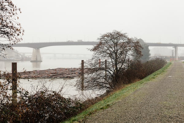
Sea Island is home to YVR airport, and to keep it safe from rising seas, the plan is to build existing perimeter dikes to a height of 4.7 metres above sea level. Climate change is forcing coastal communities around the world to figure out how to safeguard all kinds of infrastructure.Alana Paterson for The Globe and Mail/The Globe and Mail
It made a lot of sense, almost a century ago, when planners selected Sea Island to build an airport for the Vancouver region. The low-lying island was mostly farmland and offered clear approaches over the sea, a small population and flat floodplains that would be easily converted to landing fields.
In the 1920s, public planners were not expected to factor in the potential for rapid acceleration of rising sea levels. Building runways just 3.5 metres above the average height of the surface of the sea would have seemed perfectly reasonable. Today, however, the impact of climate change on sea levels is forcing coastal communities around the globe to figure out adaptation plans for all sorts of infrastructure. For Vancouver International Airport, the plan is to build a wall: raising the existing 15 kilometres of perimeter dikes to a height of 4.7 metres above sea level.
Public planners on B.C.'s coast are projecting that the seas will rise by half a metre by the year 2050 and will continue to rise for decades after that. Half a metre of water is not, by itself, the real problem. The airport, along with the rest of the development along the coast and up into the Fraser River delta’s floodplains, must be ready to face the potential for frequent, destructive forces unleashed by the combination of rising sea levels with greater winter storms, king tides and El Nino cycles.
“Extreme sea-level events that are historically rare (once per century in the recent past) are projected to occur frequently (at least once per year) at many locations by 2050,” the United Nations’ Intergovernmental Panel on Climate Change warned last fall in a special report.
Even if the great YVR wall can hold off those forces, an airport is useless without roads and bridges and high-speed transit lines that connect it to the rest of the region. Likewise, Metro Vancouver’s ports and railways – so important to Canadian trade – cannot function if links are broken. It’s all connected, except when it comes to planning for climate change.
Each of the 21 municipal governments in the metro region is responsible for its own flood-control plan and each is preparing for climate change within its own areas. Across B.C., coastal communities are trying to tackle a slow-moving but inevitable challenge, with insufficient funds, overlapping jurisdictions and gaps in knowledge and expertise.
“We need to have better co-ordination over all,” B.C. Environment Minister George Heyman says, "as we prepare for the potential for very, very significant human-health and economic impacts from climate change, if we don’t take the actions we need to prepare ourselves.”
But each community in B.C. is preparing for rising seas in its own fashion. In 2003, the B.C. government handed off responsibility for flood management to local governments. The offloading has resulted in a hodgepodge of regimes across the province, according to the Union of BC Municipalities, which is asking for B.C. to step back into the picture.
“Along the lower Fraser River and south coast of British Columbia, regional planning and funding of flood-management infrastructure has become poorly co-ordinated and underfunded since the provincial government devolved much of its role in flood protection in the mid-2000s,” a UBCM resolution from the City of Vancouver states.
Significant upgrades to flood protection are needed, the UBCM argues, but first, the province needs to resume authority.
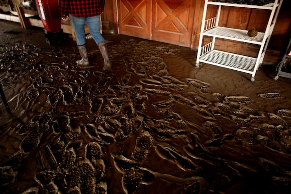
France Bournazel leaves tracks in the mud as she assesses the damage to Russell Farms Market, which she co-owns.

Hers was one of many properties damaged when the Chemainus River, laden with debris this winter, overflowed.
'All the farmers, we had a concern' about the coming flood, 'but we were told we can do nothing,' says Ms. Bournazel, shown with operations manager Tammy Calverley.Chad Hipolito/Photos: Chad Hipolito/The Globe and Mail
Fragmented by design
Farmers in the Cowichan Valley on Vancouver Island were worried about debris building up in the Chemainus River this winter – a logjam could cause damaging floods to their fields along the riverbank. They met, they talked, but they could not find an agency willing to tackle the problem. “All the farmers, we had a concern, but we were told we can do nothing," France Bournazel, co-owner of Russell Farms Market, says in an interview.
Last weekend, the farmers’ fears materialized. Ms. Bournazel got a call from one of her staff to say that her market was flooded – the river had overflowed its banks and was now running through the property. When Ms. Bournazel arrived, she had to swim through a torrent of water to find her employee who was trapped in the shop.
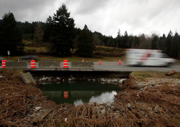
The Chemainus River was just part of the chaos caused by heavy rainfall on the weekend. The Cowichan Valley Regional District declared a local state of emergency due to widespread flooding that forced the evacuation of homes, and cut off key transportation corridors.
The disaster illustrated the challenge of preparing for sea-level rise in British Columbia. Even within the region, the responsibilities are fractured, says Kate Miller, the regional district’s manager of Environmental Services. On the Cowichan River alone, there are four jurisdictions with control over infrastructure. “You have all these moving pieces.”
While the different agencies can be pulled together in times of crisis, it is much more difficult to plan for the incremental change that is coming from rising sea levels. “It really needs to be a completely different mechanism for flood control,” she says.
Kees Lokman, an expert in adaptation planning for large-scale infrastructure, says B.C.'s coastal communities need better funding, but they also need access to coastal engineering expertise and data. These resources must be harmonized so that the region’s critical services, such as transportation infrastructure, can withstand change. “There is a lack of co-ordination on a whole range of issues,” says Prof. Lokman, of the University of British Columbia’s school of architecture.
Prof. Lokman helped produce a 2017 report on how the Port of Vancouver can prepare. And while he can recommend all kinds of strategies to protect, accommodate or retreat from rising sea levels, there is a futility in acting alone. “It becomes very tricky quite quickly," he says.
The Port of Vancouver is a critical hub for Canada’s imports and exports, facilitating trade with more than 170 world economies. “Sea-level rise could cause major disruptions to the flow of these goods and the livelihood of people directly or indirectly employed or benefiting from port-related activities,” warns the report, Visualizing the Future Port. The operations of ports rely on regional infrastructures, including rail, highways and bridges.
In the wake of the study, the port launched an initiative to work on climate adaptation, but there is a long way to go.
Tamsin Lyle is a flood-management expert who has helped shape planning for sea-level rise in the City of Vancouver. Across the region, she said, there are some excellent initiatives. But it’s not consistent. “Some of the things that are being done out here are some of the best things in the world, in terms of response and recognizing that there is a challenge that we’re facing,” says Ms. Lyle, who runs Ebbwater Consulting. But there is no consistency. “There are very mixed standards and ideas in the political, finance and policy realm, because so much has been downloaded to a local level of government."
She co-authored a flood-risk assessment for the City of Vancouver that took a mid-range sea-level rise scenario, looking 80 years into the future. Without mitigation, Vancouver will change dramatically: Stanley Park would be an island. Current emergency routes would be inundated. Cultural and historic sites in Chinatown would flood. Housing in the Downtown Eastside and school spaces in the Olympic Village would be vulnerable.
In response, Vancouver’s city planners are looking at a variety of options. Some areas will be protected by dikes. Others will sometimes be underwater, and development will have to be designed to accommodate occasional flooding. And in some cases, the city will consider retreat – the “eventual relocation of people and/or facilities and buildings in high-exposure, high-risk areas of the city.”
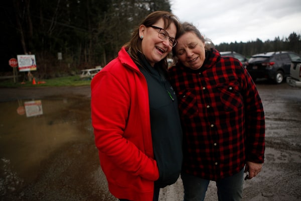
Mr. McEwan and Jolie Jamison assess the damage to their property after floods left them homeless. Cowichan Valley Regional District declared a local state of emergency.

Ms. Jamison holds a mud-covered Christmas card showing her grandson holding an ultrasound of his sibling.
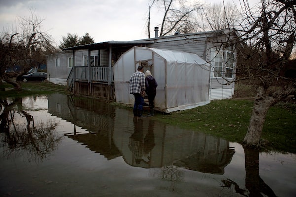
The couple look at their greenhouse, happy to discover that their strawberries survived the flood.Chad Hipolito/Photos: Chad Hipolito/The Globe and Mail
Retreat, but where?
This spring, the 14 Nuu-chah-nulth First Nations on the west coast of Vancouver Island will gather to talk about how to prepare for climate change. Hugh Braker, an elected councillor of the Tseshaht First Nation, will focus on flood concerns. Sea-level rise poses a threat to the Tseshaht’s reserve lands – as is the case for many Indigenous communities up and down the coast.
“We’re going to lose a lot of land,” he says. “We don’t have the money to build giant walls. My main reserve is along the river, and all of our other reserves are along the ocean. So I don’t see any option for us, really, except retreat.”
If the lands set aside by Canada for the Tseshaht people become uninhabitable, they will need somewhere to go. When his band council met with officials from Indigenous Services Canada last year, Mr. Braker asked if Canada is ready to locate alternate reserve lands. “And the answer I got was, ‘We don’t have a plan and, no, we don’t plan on getting more land for First Nations.’ ”
Leslie Michelson, a spokesperson for Indigenous Services Canada, said in a statement that the vulnerability is recognized. But she said that the solutions need to be considered as part of a larger picture.
“In regard to a retreat option in the face of rising oceans, this would likely involve the entire B.C. population residing along the coastline, including First Nations communities. Such a situation would demand a multidepartmental response at all levels of government to move affected B.C. residents, including First Nations, out of harm’s way.”

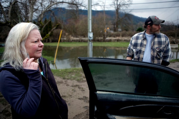
Crofton area dairy herdsman Scott Bennett gestures to describe the waist-deep water from the Chemainus that washed through his property.
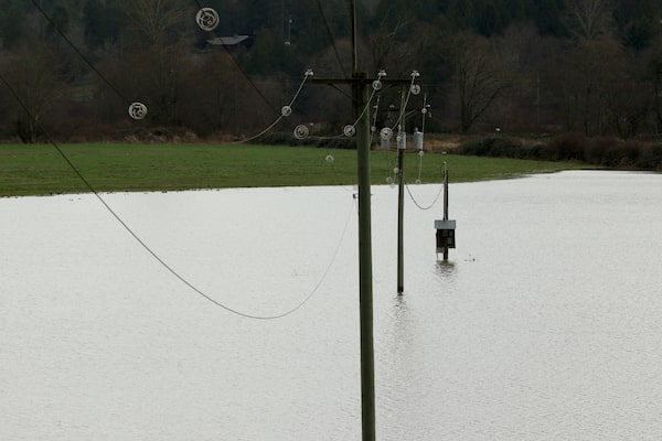
In a farmer's field, telephone poles still lie partly submerged.
The floods washed away this section of road along Highway 1.Chad Hipolito/Photos: Chad Hipolito/The Globe and Mail
A new approach in the works
The B.C. government announced on Tuesday that it will provide disaster-relief funds for residents who experienced flood damage from the recent heavy rains. Prevention, in the long run, will be less expensive than responding to disasters, the province says.
B.C.'s Environment Ministry is working on a climate-change preparedness and adaptation strategy, which the minister hopes will be ready this year.
“The province has an important co-ordinating role,” Mr. Heyman said in an interview. “We’re working with all levels of government and Indigenous nations to have a plan that can encompass everyone in B.C., rather than a hodgepodge of different responses."
But he stopped short of committing to put flood control back under provincial responsibility.
“We certainly have an interest in ensuring that there’s a uniform and sufficient program across British Columbia,” he said.
Something, he acknowledged, that B.C. does not have now.
With reports from Wendy Stueck in Vancouver
We have a weekly Western Canada newsletter written by our B.C. and Alberta bureau chiefs, providing a comprehensive package of the news you need to know about the region and its place in the issues facing Canada. Sign up today.
 Justine Hunter