
Sandbags left over from the previous year's floods line Seneca Avenue on Algonquin Island. Erosion and changing water levels threaten to further whittle away the Toronto Islands.Cole Burston/The Globe and Mail
The biggest of the islands in Toronto Harbour is a popular destination for strolling, picnics and swimming that sweeps in a great arc from just beyond the ferry docks in the east to the airport in the west. But the islands were built by wave action, and the main island was at increasing risk of being undone by it, with the insatiable lake always nibbling away and threatening to split the land in two.
Record-high water levels in recent years brought floods that highlighted the vulnerability of the islands to catastrophic events, but erosion poses an ongoing existential threat to the archipelago.
“This is a destination for all Toronto,” said Councillor Joe Cressy, whose ward includes the islands. “[Protecting] a citywide destination with more than a million annual visitors, that is a worthwhile investment.”
The importance of what is essentially a vast central park was highlighted this summer, after pandemic restrictions kept it largely closed for months. When the islands reopened to the general public in late June, visitors were quick to return to the urban escape, even with capacity on the ferries further limited by physical-distancing rules.
Mr. Cressy warned that the land for a park this size could never realistically be assembled downtown if the islands were allowed to wither away.
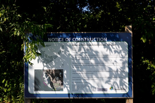
A sign offers details of the Gibraltar Point Erosion Control Project.Cole Burston/The Globe and Mail
A number of projects to tackle the twin threats of erosion and high water are under way or being considered in an attempt to safeguard the islands for future generations. The work, which does not yet have an overall price tag, is being funded by the city and led by the Toronto and Region Conservation Authority (TRCA).
Raising a section of the main road to keep the big island intact was one part of emergency work done this summer to shore up the archipelago. Other projects included finishing an artificial reef to shield fast-eroding Gibraltar Point at the southwest tip and building a protective groyne – a breakwater that extends perpendicular to the shore – nearby.
Plans are also brewing for various measures to guard against water damage, including the possibility of a new promenade, groynes and beaches to the east of the Ward’s Island ferry dock. An environmental assessment this year will look at projects with a total cost in the range of $13.9-million to $16-million. But no matter which options are chosen, restorative work will be needed indefinitely as the lake continues to sculpt and reshape the islands.
Meg St. John, a senior project manager with the TRCA, noted that new sand planned for the Gibraltar Point area will have to be supplemented regularly. The plan is to spread 15,000 cubic metres there next year, then plant vegetation in an effort to slow erosion. However, the same quantity of new sand will likely be needed every three to five years.
“Beaches are natural systems, so the sand is eventually going to migrate from the Gibraltar Point area,” Ms. St. John said. “We’re going to need to take an adaptive management approach to see when that sand needs to be replenished, when we need to do more dune restorations.”

Hanlan's Point in the 1880s, as shown in a wood engraving based on a drawing by Frederic B. Schell. The islands only became islands in the 1850s, when the water took away the eastern end of what was once a peninsula.Toronto Public Library

The Gibraltar Point lighthouse, left, is shown in 1958. The 1950s was when many of the summer homes and businesses on the island were expropriated and demolished, making way for the parks we have today.Richard Cole/The Globe and Mail

Masked people disembark the ferry at Ward's Island. COVID-19 restrictions had a chilling effect on travel in the spring and summer, but when the islands reopened in June, visitors came back quickly.Cole Burston/The Globe and Mail
The islands were formed by sand drifting west from the area around the Scarborough Bluffs, creating a long peninsula that permanently broke free at its eastern end in the 1850s.
The site, already popular as a day trip for early colonists, soon burgeoned with summer homes, hotels and other businesses. There were butcher shops, laundries and the baseball diamond where Babe Ruth hit his first professional home run. Most of this was expropriated and demolished in the 1950s, when the city was creating the park we know today.
Jimmy Jones, who at 90 is a sort of island elder statesman and amateur historian, paints a vivid picture of the lost community as he bicycles around one late summer day.
He points out the original location of the 19th-century church and where a schoolmate who went on to become a federal cabinet minister had lived. The Austrian pine whose cones he and his sister used to make Christmas decorations still stands across from the site of his childhood home. The house is long gone and, decades later, he remains upset about the way most of the island residents he knew were removed.
“The island needs people to live on it,” said Mr. Jones, who is sometimes referred to as the community’s unofficial mayor. “Guarding the island, so to speak.”

A park supervisor looks at erosion on a small area called Snake Island in 2007.Kevin Van Paassen/The Globe and Mail
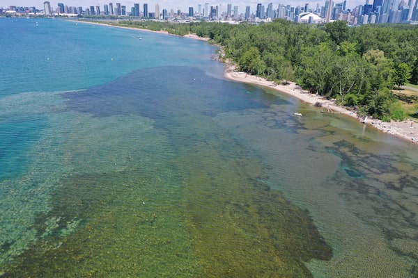
Meanwhile, the land itself was changing, perpetually eroding but growing, too. In a dramatic example, a lighthouse that was originally only eight metres from the water’s edge is now 20 times as far inland. The paving of much of the shoreline to the east slowed the supply of new sand drifting toward the islands, though, and then the building of the Leslie Street Spit further blocked the flow. The result is land eroding faster than it is being replenished.
By 2004, when a severe storm hit, Gibraltar Point had retreated so much that the washroom at the spot was at risk of being lost. Engineers subsequently contracted by the TRCA determined that land there has been vanishing at an average of four metres annually.
The popular spot to view the Canadian International Air Show, which would normally be happening this weekend, kept shrinking. The land between the open lake and an area known as the Trout Pond has since narrowed into an isthmus. Without intervention, the two bodies of water would have eventually become one.
Although a bridge could easily span such a breach, Ms. St. John explained that an island split would have endangered an important hatching area for fish by making the Trout Pond subject to the dramatic temperature inversions of the open lake, where very cold water wells up from the depths. And she dismissed the idea that nature be allowed to take its course, noting that there has already been extensive human manipulation of the area.
“Whatever was supposed to be, quote, unquote, natural, we can’t get back to,” she said.
“So when you talk about sort of trying to maintain what would naturally be there, we are trying to maintain that. We’re trying to protect these natural ecosystems, given that we’re operating in an unnatural ecosystem.”
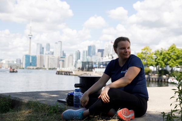
Meg. St. John, shown on Ward's Island, is a senior project manager with the Toronto and Region Conservation Authority. She says it'll be important to monitor where sand needs to be replenished on the beaches with the understanding that it will migrate away.
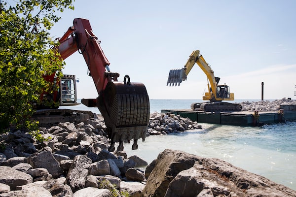
This summer, construction crews have been building a groyne on the island to shelter Gibraltar Point from erosion.
Gibraltar Point's defences also include an artificial reef built in 2019 and 2020 to reduce the force of the waves.Toronto and Region Conservation Authority
Tactics for Gibraltar Point include tonnes of rock dropped into the shallow waters immediately to the west last year and this year in an attempt to dampen the force of the waves. And a 60-metre groyne is being built to further shelter the spot.
“It’s amazing the power of Lake Ontario,” said Jet Taylor, another senior project manager at the TRCA. “Any weak spots [in a barrier] and it’ll fail.”
Other parts of the island have received their own interventions against water incursion.
Workers raised the section of road west of the emergency services station so high water wouldn’t flood it and stop crews from reaching people in distress. And the eroding shoreline adjacent to the Ward’s Island ferry dock was buttressed with large hunks of limestone from a quarry in the Kawarthas, northeast of Toronto.
Longer-term fixes to mitigate flooding and erosion are being considered through the environmental assessment. Record-high water in 2017 and 2019 was met with sump pumps and large sandbags, which are effective but aesthetically out of character with the parkland setting.
“We don’t want to have to be doing sandbags all the time, like year after year after year,” Mr. Taylor said. “We’re trying to get it some more permanent and cost-effective solutions in place, so we’re prepared for the flooding moving forward.”
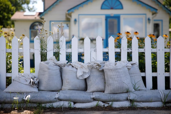
Sandbags are piled near a fence on Algonquin Island.Cole Burston/The Globe and Mail
One simple tactic against high water could be a vegetated berm, a low hill, to block it from pouring onto the land. More elaborate interventions to protect the shoreline could include building groynes at the northeast end of the island and then creating new beaches.
The options, laid out in a 2019 consultants’ report, go beyond the current standard of planning. Instead of preparing for once-in-a-century water levels, they aim to protect against 500-year high water, which is projected to rise another 20 centimetres.
The report from W.F. Baird & Associates Coastal Engineers makes clear that such high water is not, statistically, a remote possibility.
“The 500-year flood event has a 0.2 per cent chance of being equalled or exceeded in a given year, which results in a 6 per cent chance of being equalled or exceeded at least once in a 30 year period,” warns the report, adding the underline for emphasis.
Cole Burston/The Globe and Mail
 Oliver Moore