How do you design a flood-proof city? You don't. How do you prepare for extreme weather in the era of climate change? You let the water come.
That's the approach that landscape architects and other designers are taking to address the threat of flooding in urban areas: designing cityscapes that are designed to absorb water; and riverfronts and lakefronts that are meant to get wet.
Last week's funding announcement in Toronto of the Port Lands Flood Protection Project, to which Prime Minister Justin Trudeau and his Ontario and Toronto counterparts committed nearly $1.2-billion, reflects a big bet on this model.
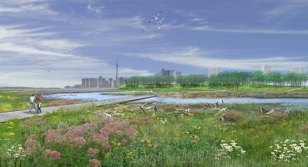
That project, based on a design led by landscape architects Michael Van Valkenburgh Associates and urban designer Ken Greenberg, is not based on heroic engineering. It reshapes the mouth of the Don River in downtown Toronto; where the river once meandered into a marshland at Lake Ontario, it has been shaped into a concrete channel for more than a century. The new project will reverse some of those changes. "Rather than building high dikes," Greenberg says, "it creates a broad expanse of parkland that would be flooded in times of severe events – but would also set up a new neighbourhood."
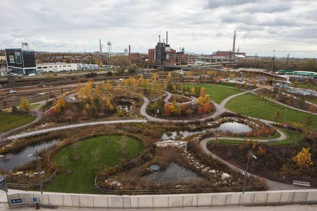
The plan for the “Don Mouth Naturalization Project” includes a large new park and estuary in the Lower Don Lands.
Waterfront Toronto image
The Don River runs south to Lake Ontario, but makes a last-minute right turn in the concrete-lined Keating Channel. The new design will keep that in place but add a second outlet, this one broad and lined by a bowl-shaped park. This green space will be the heart of new neighbourhoods, housing tens of thousands of people, that can only be built because the risk of flooding has been reduced.
The adjacent Villiers Island, a 54-acre chunk of city, is already being master-planned. This scheme is urban design and landscape architecture, linked with flood protection and adaptation to climate change – the effects of which are already showing themselves in more frequent floods such as those on the Ottawa River this year. "This is a problem that requires lateral thinking, stepping out of the individual silos," Greenberg says.
It also demands a new conceptual approach to the problem: "Allowing the river to shape the city, rather than the city to subvert the river," says Nina-Marie Lister, a planner and ecologist at Ryerson University. The planning of Corktown Common, a nearby Toronto park that also provides flood protection, is a good example of such flexible thinking, says Lister, who is also a member of the Ryerson Urban Water Centre. This is "a smarter way to design," she says. "But we're just not very good at it, institutionally."

The slide and sand play area at the Corktown Common Park in Toronto.
Deborah Baic/The Globe and Mail
Why? Lister talks about rivers as "living systems," and governments, civil engineers and urban planners don't deal well with living systems.
"We tend to use machine metaphors, and river systems don't work that way," Lister says.
The challenge is to create city spaces that "prepare for routine-but-inconsistent flooding," she says. "We know it's going to happen, but it's unpredictable. Planners don't like that idea. It freaks us out."
In the Netherlands, a series of 39 projects dubbed "Room for the River" is allowing for such uncertainty, creating floodways and channels that direct floods away from vulnerable areas. And while Lister points out that those rivers – indeed much of the Dutch landscape – is heavily engineered and managed, she says, "there are huge lessons for Canadian cities. … How do you design for something you don't want?"
Smaller landscape interventions, in large numbers, can help, by diverting stormwater out of storm sewers and river systems. The main tools include bioswales – small gardens that capture and absorb storm-water – and green roofs. "For stormwater, green roofs are an incredible solution, because you have all this unused roof space," says Liat Margolis, a professor of Landscape Architecture and director of the Green Roof Innovation Testing (GRIT) Laboratory at the University of Toronto.

The Green Roof Innovation Testing Laboratory features several different garden beds.
PHOTO COURTESY OF THE DANIELS FACULTY
Indeed there is evidence that green roofs absorb substantial amount of rainwater. And a cistern, or holding tank, can keep it out of storm sewers and the ground; Margolis and GRIT Lab are studying the combination of both systems. The rainwater will be used to irrigate green roofs, and the green roofs absorb some of the pollutants in the water. "We know that green roofs are very effective in flood reduction," Margolis says. "Can we maximize that and also clean the water along the way?"
The City of Toronto's chief planner, Jennifer Keesmaat, cites the city's pioneering 2010 green roof policy as an important ingredient in reducing the quantity and quality of rainwater. She also cites Raindrop Plaza Park, a new small park designed to address flooding in one specific area of the city by absorbing rainwater.
But the Don River move, she says, reflects a larger lesson. "It is about mitigating the mistakes of the past," Keesmaat says. "It was the unnatural rerouting of the Don that caused this threat. We have to spend $1-billion now to get it right because there was a planning philosophy that we can control water, and it turns out that we can't."
The new plan for the mouth of the Don River, “creates a broad expanse of parkland that would be flooded in times of severe events – but would also set up a new neighbourhood,” says urban designer Ken Greenberg.
Waterfront Toronto image
So if we can't control flooding, should we get out of its way? This is a perennial debate every time an urban area is hit by flooding: whether building in a flood plain is smart to begin with. More than 1.8 million Canadian households are in flood plains. This spring's Quebec floods led to calls for disaster relief and few changes in planning, just as the major Calgary flood of 2013 has resulted in the rebuilding of many damaged buildings located in the floodplains and no major shift in the city's land use policy. Frank Frigo, senior planning engineer with Calgary's Water Services department, says the city is carefully controlling flood risk for new suburban development.
"The challenge for us is the existing city," he says, particularly the core. "Because of historical accident, our most intense development and infrastructure is at risk." Calgary has carefully studied a full "room for the river" approach, but the costs of abandoning land in flood plains would simply be too high.
Alec Hay, a civil engineer and expert on resilience – the capacity of a community to survive and spring back after a disaster – says that response, of relying on controlling water levels, won't always be adequate.

Corktown Common Park is a good example of flexible planning that allows “the river to shape the city, rather than the city [subverting] the river,” says Nina-Marie Lister, a planner and ecologist at Ryerson University.
Deborah Baic/The Globe and Mail
"The biggest thing people can do is pay attention to where they live," he says. "If you live in an area prone to flooding, don't be surprised if you flood."
Working with residents in Calgary after the 2013 disaster, Hay found "there were people who would say, genuinely, 'It's not going to happen again.' … And, of course, it will."
Designing a new swath of city to be flood-proof is one thing; fortifying or even abandoning existing waterfront neighbourhoods is, politically, another thing entirely. But if rivers are living things, and we are living alongside them, we should be prepared for them to go wild.