
Pedestrians walk past hammocks on the Halifax waterfront. In 2003, the Nova Scotia capital faced a moment of reckoning about sea levels when Hurricane Juan created devastating floods. But while the city seemed destined to become a leader among coastal cities in preparing for disaster, it’s fallen behind in the years since.Darren Calabrese/The Globe and Mail
Graphics by Murat Yükselir
The storm seemed mild by Nova Scotia’s standards: winds reaching only about 70 kilometres an hour, a mere gale on the Beaufort wind-force scale. But the tides on the Halifax waterfront were higher than usual on Jan. 4, and harbour levels rose further, pushed by the accompanying low pressure system. People who manage or own properties and businesses near the water understood it was a recipe for flooding, and in what has become almost a ritual, arrived at their premises ready to respond.
Mike Condy was at his popular basement bar, the Lower Deck, waiting to see whether it would be safe to open for the night. When harbour waters rise, his place is among the first to flood. At 8:30 p.m., an hour and 40 minutes before high tide, the weather was calm and unseasonably warm, so he called in his employees, and Signal Hill, the rock band scheduled to take the stage that evening.
“It wasn’t 15 minutes later that the wind picked up and waves started breaking up over the boardwalk,” Mr. Condy said. “By 9:30, we were probably three or four inches deep.”
Flooding has become an almost annual event at the Lower Deck during the decade or so since Mr. Condy bought it. But the wind from the southeast was piling so much water against the harbourfront that it also threatened other properties. Peter Bigelow, director of planning and development at Waterfront Development Corp. (WDC), a provincial Crown corporation that owns swaths of the waterfront, watched as the waves crept up the sides of the coffer dam that keeps the harbour water off the construction site of a $200-million development called Queen’s Marque.
With 20 minutes to go before high tide, the wind suddenly shifted.
“We’re just standing there,” he recalled, “and then seeing the flags on the buildings luff and then change direction. As soon as that happened, our property manager said, ‘We just dodged a bullet.’”
The harbour’s surface receded abruptly. Mr. Condy and his employees began swabbing the Lower Deck.
Not long ago, a storm like the one on Jan. 4 would have warranted little vigilance. “Historically, it may have been that ‘perfect storms’ had to happen in order for the Halifax waterfront to be impacted,” Mr. Bigelow said. But tide gauges attest that local sea level rose about 3.3 millimetres a year during the 20th century – among the fastest rates observed anywhere in Canada. That is partly because the city is slowly sinking as the Earth’s crust continues to adjust from the last ice age. “Now we have more water in the harbour, [thanks to] sea-level rise,” he said. “It takes less and less, in terms of conditions, to create flooding.”
Halifax Harbour’s surface is expected to rise by at least twice that historical rate – and potentially faster – during the coming century. Just a few decades hence, the rare but epic floods etched in the memories of Nova Scotians could become commonplace. Preparations for that future have barely begun.
A couple of years ago, Turner Drake & Partners, a commercial real estate consultancy, identified properties along the waterfront with a combined assessed value of $446-million that were at elevations lower than five metres above sea level. (This estimate excludes the current market value of those buildings, not to mention new ones under construction.) Turner Drake argued properties at these low elevations will be at high risk of flooding in the near-term.
“If you look at the five-metre contour [line], you can see that basically all the buildings along our waterfront, from the casino right through to Bishop’s Landing and the Port of Halifax, all of those buildings – the complete line of them – would be impacted,” said Alexandra Baird Allen, manager of the firm’s economic intelligence unit. “Perhaps catastrophically.”
Halifax flooding scenarios
Flooded landmark
SOURCE: NSCC MARITIME COASTAL FLOOD RISK MAP
SEA CHANGE: ABOUT THE SERIES
The world’s oceans have been rising in lockstep with global temperatures since the mid-1800s – and the pace is accelerating. In this five-part series, Sea Change, The Globe and Mail examines how Canada’s most vulnerable coastal communities are preparing for an inexorable force that will reshape their coastlines – in potentially catastrophic ways – for generations to come.

0
5
KM
Dartmouth
Halifax
NOVA SCOTIA
Coastal sensitivity
to climate change
Low
Medium
High
MURAT YUKSELIR / THE GLOBE AND MAIL,
SOURCE: CANCOAST

0
5
KM
Dartmouth
Halifax
NOVA SCOTIA
Coastal sensitivity
to climate change
Low
Medium
High
MURAT YUKSELIR / THE GLOBE AND MAIL,
SOURCE: CANCOAST

0
5
KM
Dartmouth
Halifax
NOVA SCOTIA
Coastal sensitivity
to climate change
Low
Medium
High
MURAT YUKSELIR / THE GLOBE AND MAIL, SOURCE: CANCOAST
PART 1: HALIFAX
Population: 403,390
Projected sea-level rise by 2100: 57.7 to 90.3 cm
WHAT THE SCIENCE SAYS
Read Matthew McClearn's primer on the science behind this series.
After Hurricane Juan
The moment when Halifax began reflecting on what sea-level change would mean to its future can perhaps be traced back to late September, 2003, when Hurricane Juan struck the city.
The storm pushed water levels in the harbour nearly a metre above the highest high tides, spilling seawater into the downtown core. Haligonians had not witnessed such water levels since the 1930s, with some people reporting starfish all the way up to Lower Water Street.
A 2004 municipal document noted that sea-level change “will seriously impact shoreline infrastructure such as seawalls and wharves and will threaten low lying buildings.” Within a few years, Halifax Regional Municipality’s council began gathering data to better understand the risks. It surveyed the harbour with light detection and ranging (LiDAR), a remote sensing technique that uses aircraft-mounted laser pulses to create high-resolution models that can identify areas that could flood.
The municipal council eventually settled on a scenario in which the water in the harbour will be 73 centimetres higher in 2100, and storms would drive the levels 2.7 metres above that as the basis for future policy development. It amended the land-use bylaw to require that residential units be constructed at least 3.8 metres above the mean sea level for North America established in 1928.
Halifax appeared destined to become a leader among coastal cities in preparing for rising sea levels. During one brainstorming session several years ago, consultants even envisioned building a third bridge across the harbour’s mouth that would allow ships to pass in good weather but have the capability to become a barrier to defend against storms. The idea was as fanciful as it was ambitious – it’s doubtful Halifax could afford anything of the sort.
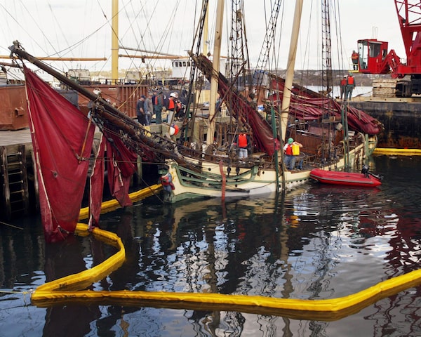
Halifax harbour, 2003: The schooner Larinda is raised from the water after it was battered by a neighbouring vessel and sank. The storm pushed water levels nearly a metre above the highest high tides.Andrew Vaughan/The Canadian Press

Halifax harbour, 2018: Cable Wharf, once a soggy mess after the flooding of Hurricane Juan, now overlooks the construction site for the Queen’s Marque, an ambitious waterfront development project.Darren Calabrese/The Globe and Mail
But as memories of Juan receded, so, too, did the preparations. Many of the officials who had driven them retired or moved on. A recent published draft of the city’s plan for future development mentions rising sea levels only in vague, general terms. “In some ways it’s in a pause moment,” architect John Crace observed.
It’s an unfortunate moment to take a breather.
Halifax’s waterfront had for years been a relatively static, backward-looking place. Floating relics such as the aging scientific vessel CSS Acadia and the Second World War-era corvette HMCS Sackville recall the city’s maritime past. Riding the distinctive blue and white ferries over to Dartmouth – the oldest continuous saltwater service in North America – feels much the same as it did in the 1980s.
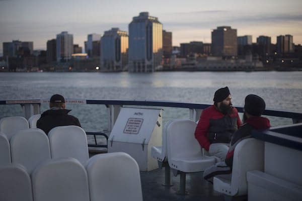
Commuters ride the ferry from Dartmouth, N.S., to neighbouring Halifax.Darren Calabrese/The Globe and Mail
During the past decade, however, the city’s tightly knit planning and design community reimagined the waterfront. They sought to eliminate parking lots, build new parks and trails and encourage foot traffic. The municipality produced highly prescriptive guidelines dealing with everything from how to incorporate heritage buildings into new structures to what cladding materials should be used for rooftop penthouses.
That vision is now being realized. Mandated to redevelop 120 acres of provincial waterfront lands, the WDC is the primary landowner along Halifax’s downtown waterfront. “We probably have four sites that are in planning or under construction along the waterfront,” Mr. Bigelow said.
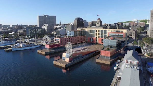
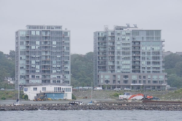
Queen’s Marque is the plan’s crown jewel. It will include retail and restaurants, 100 hotel rooms, 130 residential apartments and more than 10,000 square metres of office space. Some of it will jut out into the harbour on three new wharves. The developer, Armour Group, has experience on the Halifax waterfront: In the 1970s, the family-owned company turned a collection of 19th-century waterfront warehouses into a fashionable shopping and dining destination called the Historic Properties. The estimated $200-million cost of Queen’s Marque is massive by East Coast standards.

The Queen’s Marque, today: On a construction site separated from the water by a coffer dam, workers lay the groundwork for the $200-million waterfront redevelopment.Darren Calabrese/The Globe and Mail
The Queen’s Marque, tomorrow: An artist’s rendering shows the completed development. Queen’s Marque will sit more than a metre above the existing boardwalk and 2.9 metres above the 1928 sea level.Armour Group/Handout
Taking a cue from submarines
The city’s bylaws and design manuals remain largely silent on how developers should plan their waterfront buildings to cope with future flooding. “Climate change, ocean level rising, doesn’t get a lot of attention,” said Mr. Crace, the Halifax architect.
Mr. Crace is a member of the Design Review Committee, which is charged with ensuring proposed new buildings meet municipal requirements. In keeping with the city’s focus on appearances, the committee carefully considered Armour Group’s placement of shop fronts, its choices in building materials and its decision to not place canopies and awnings along its Lower Water Street side. But minutes from design committee meetings suggest the topic received little or no discussion.
“We don’t have the power to insist on, say, taking more care in mitigating ocean level rising risk,” Mr. Crace explained.
This regulatory vacuum left Armour Group’s CEO, Scott McCrea, largely to his own devices as he approached one of the most difficult decisions of his career: how high Queen’s Marque’s main floor should be elevated above the high-tide mark. Since the building will have no residential units on the main floor, the city’s existing bylaw did not apply. Mr. McCrea had witnessed Juan’s wrath, and felt he had to take additional precautions. “A code is a code; it’s your base minimum,” he said. “It doesn’t mean it’s necessarily right, or is what’s required if your project has a 100-year minimum useful life.”
But Mr. McCrea had another problem. A bylaw prevents new buildings in downtown Halifax from blocking the view from Citadel Hill, the colonial fortress overlooking the harbour. Raising Queen’s Marque’s main floor too high might mean an entire storey would have to be eliminated.
Armour Group met with officials from the Bedford Institute of Oceanography and consulted their projections on sea-level rise. “From that, we added statistical high water, so the maximum high water you would achieve through full moon and tidal action,” Mr. McCrea said. And then Armour Group added the effects of an extreme storm – Hurricane Juan – including wave action and the wind-driven rise in water levels known as storm surge.
All considered, Armour Group settled on situating its ground floor 2.9 metres above the 1928 mean sea level. Queen’s Marque will sit more than a metre above the existing boardwalk.
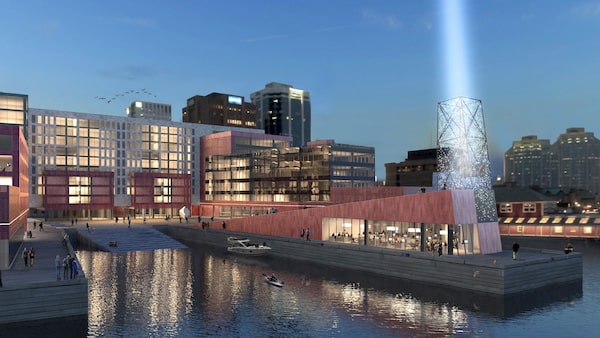
The Queen’s Marque’s designers consulted an oceanographic institute for their predictions about how much sea levels would rise in the future.Armour Group/Handout
Armour Group will also put most of Queen’s Marque’s electrical infrastructure above grade.
Mr. McCrea saw what high water could do to an electrical system when Juan flooded the Historic Properties. The electrical vault there lay below grade; if the water running through the streets got in, passersby could be at risk of sudden death by electrocution. Mr. McCrea and other employees rushed to the site and tried to shoo pedestrians away. Seawater eventually did get in, and the vault exploded, although no one was hurt.
At Queen’s Marque, backup generators will be on the roof.
Two levels of subgrade parking will be waterproofed, but the building’s parking entrance presents an obvious flooding risk. Although the design has not been finalized, Mr. McCrea said it will accommodate temporary metal dams. The parking garage also will have areas that can fill up without causing damage. Electrical components that couldn’t be relocated – such as heat pumps and some boilers – will sit on raised pads inside watertight rooms resembling those found aboard submarines.
“Our approach to this is more nautical than land-based,” Mr. McCrea said. “We’re looking at the kinds of things you have to do in nautical environments, on a boat, to seal areas.”
Mr. McCrea is not the first developer to incorporate such considerations into his designs. King’s Wharf, an extensive multiuse project across the harbour in Dartmouth, was built on the site of a defunct, low-lying shipyard; the entire site was raised a couple of metres and surrounded by a retaining wall.
The King’s Wharf project in Dartmouth, N.S.Matthew McClearn/The Globe and Mail
The municipality is also protecting some of its own infrastructure. In a recent business plan document, Halifax Water, the city’s water and waste-water utility, said recently constructed waste-water facilities in Halifax and Dartmouth were designed to accommodate a one-metre sea-level rise.
Yet unco-ordinated measures are unlikely to produce a meaningful increase in the city’s overall resilience. They may also have unintended consequences.
Mr. McCrea warned that downtown Halifax could become a “checkerboard” as new developments are raised above existing properties. The implications could become apparent during future storms. “You can see how my situation can make my neighbour’s worse, because you’re almost creating a dam or containment around them,” he said. “I don’t think people have thought that through.”
The William Robertson & Son ship chandlery stands immediately south of the Queen’s Marque site. Built in 1840, it housed a marine-supply shop for nearly a century. Now part of the Maritime Museum of the Atlantic, it has been restored to an early 20th-century appearance. The provincial Transportation and Infrastructure department, which manages the property, said the museum has no plans to change its infrastructure, and declined further comment.
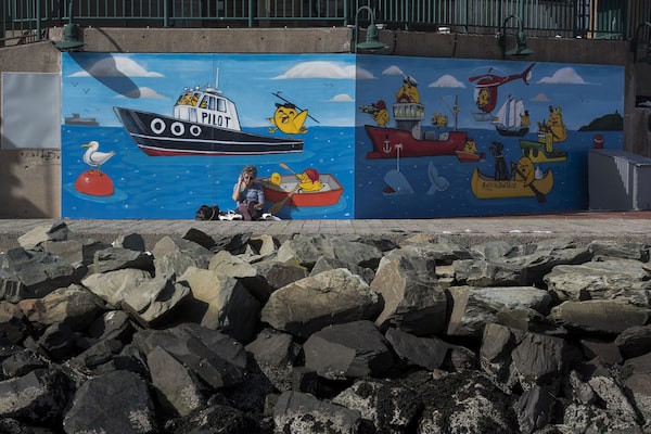
A woman rests near a nautically themed mural near a rock breakwall along the Halifax waterfront. A woman rests near a nautically themed mural near a rock breakwall along the Halifax waterfront. The Halifax Regional Municipality is working to educate citizens about the effects of rising seas on their community.Darren Calabrese/The Globe and Mail
“How is this going to play out?”
Alex MacDonald, a climate-change specialist with Halifax Regional Municipality, acknowledged the challenge ahead. “Sea-level rise is accelerating,” he said. The municipality is educating citizens on the potential effects, and has created regional teams that will lead disaster preparations in communities outside the city. And it is flying new LiDAR missions to gather data on all 2,400 kilometres of its coastline.
But Mr. MacDonald said he is not aware of any initiative that addresses the aging warehouses, museums, restaurants and the bustling boardwalk, much of which sits just a metre or two above today’s high-tide mark. Nor was the Lower Deck’s Mr. Condy. “Nobody has ever drawn up a plan or said to me, ‘We’re going to fix this, Mike,’” he said.
What Halifax needs is a comprehensive waterfront development plan, Mr. Bigelow said. WDC is now drawing one up. It’s looking to other port cities such as New York, Boston and Seattle for inspiration. “This is probably more important to us than it is to others,” Mr. Bigelow said. “We don’t mind starting this conversation.”
In January, 2017, the day after construction began at Queen’s Marque, the U.S. National Oceanic and Atmospheric Administration released its latest regional projections for U.S. ports. It recommended port cities prepare for a rise in sea levels of 2.5 metres by 2100 for the most consequential infrastructure – substantially above anything Halifax has contemplated to date.
Mr. McCrea said he believes he relied on the best available science, and loses no sleep over such forecasts. He doubts he will see another Hurricane Juan in his lifetime. If one arrives, “we might have four or five inches of water on our podium, maximum,” he predicted.
He could be right. It’s anyone’s guess whether a warming climate will hurl more violent storms Halifax’s way. Although unusually violent by local standards, Juan was only a weak Class 2 hurricane, a meteorological weakling in comparison with the Class 5 storms that ravaged the Caribbean and southern United States last summer.
The bad news is that if Queen’s Marque lasts anything near as long as Mr. McCrea hopes, it will experience many Juan-like events. The reason is that even slight sea-level increases radically alter the math governing the expected frequency of storms.
Halifax’s tide gauge data go back more than a century. Thomas James, a solid-earth geophysicist with Natural Resources Canada (NRCan), said the data establish that for every 10 cm that relative local sea level rises, “you’re going to be getting three times as many inundation events as you were before.” To put that in perspective, a 2016 NRCan report predicted Halifax could get 40 cm between 2010 and mid-century. By then, the city could experience Juan-like flooding “on average more than once every five years. Extrapolating to the end of the century, these levels would occur even more frequently.”
According to real estate consultancy Turner Drake, local lenders or insurers have not yet responded to the mounting risk. But when they do, it could bring Halifax’s waterfront renaissance to a screeching halt. “How is this going to play out?” Ms. Baird Allen asked. “Will it be through increased difficulty in obtaining financing? Will it be insurance premiums that make it not feasible to develop on the waterfront?
“That will be interesting.”