
An old farmhouse lies next to Constant Creek in Mount St. Patrick, Ont., a community along Ontario's Opeongo Line. In the 19th century, the settler's road was a lifeline for farmers eking out a living from unforgiving soil.Dave Chan/The Globe and Mail
We are walking a rough path not that different from what the Opeongo Line would have looked like when it was first cut through the bush more than a century and a half ago. The sign marking the Opeongo Heritage Trail tells us that the first settlers came here “in quest of a better life.”
The branches close in overhead. The stifling August heat, the mosquitoes, the fetid smell of a nearby swamp. Go back in your mind. It is late in the 1850s. You escaped the Irish Famine, or the wars and purges in Central Europe. You survived the coffin ships, where it was common for a third of the passengers to die on the journey. You made your way to Farrell’s Landing on the Ottawa River, 90 kilometres northwest of what is now the nation’s capital, and then travelled west another 100 km, along the Opeongo Line to this spot, where you were promised free land and a new start.
But the soil is thin, and washes away once you’ve cleared the trees. The stones break your back and your plow. You fail. Your neighbours fail. Almost everyone who tries to farm along the Line fails.
“The harsh terrain would prove inhospitable,” the sign understates. Maybe you gave up and moved on. Or maybe you found land nearby not quite so bad and made a hardscrabble living there. You became part of the settler culture of the Ottawa Valley, one of the most beautiful, and poorest, parts of Ontario.
Twenty-five summers ago, as a writer for the Ottawa Citizen, I traversed and then wrote about the Opeongo Line, the road that opened the Upper Ottawa Valley to settlement. The original track had long since become highway and county road, but the route remained intact, although the culture that had formed around it was already disappearing. “Just as the settler heritage of Ontario is being submerged by time and new immigration, so also the Opeongo may be doomed to disappear, a victim of fading memories and road improvements,” I wrote then. New waves of immigration from China, India and other developing countries were transforming the economy and culture of the province. So many people lived just outside Toronto that their cities were given a new area code that year: They became the 905.
The culture of the old Line is my culture, too. My great-great grandfather was among the first settlers in Muskoka, a couple hundred kilometres to the west, on the other side of Algonquin Park. Muskoka was transformed, and the old culture submerged, by tourism. But I always wondered: What had happened to the people along the Line? A quarter-century after I last wrote about it, what was left of this corner of Old Ontario, of the descendants of Irish and Polish and English settlers, of their fierce Catholic and Protestant loyalties, of their economy of just getting by? The answer to that question starts with a conversation taken up where we left off in 1993.

THE HISTORIC OPEONGO LINE
QUEBEC
Ottawa
416
ONTARIO
Kingston
401
U.S.
0
75
Lake Ontario
KM
Algonquin
Park
0
13
NORTH
KM
Whitney
Madawaska
Barry’s Bay
Wilno
Brudenell
Foymount
60
Clontarf
Esmonde
Constant Creek
Dacre
Scotch Bush
Balaclava
Mount
St. Patrick
Ferguslea
Renfrew
Farrell’s Landing
Castleford
MURAT YÜKSELIR / THE GLOBE AND MAIL,
SOURCE: TILEZEN; OSM CONTRIBUTORS;
GOOGLE MAPS; OTTAWA VALLEY TOURIST
ASSOCIATION

THE HISTORIC OPEONGO LINE
QUEBEC
Ottawa
416
ONTARIO
Kingston
401
U.S.
0
75
Lake Ontario
KM
Algonquin
Park
0
13
NORTH
KM
Whitney
Madawaska
Barry’s Bay
Wilno
Brudenell
Foymount
60
Clontarf
Esmonde
Constant Creek
Dacre
Scotch Bush
Balaclava
Mount
St. Patrick
Ferguslea
Renfrew
Farrell’s Landing
Castleford
MURAT YÜKSELIR / THE GLOBE AND MAIL, SOURCE:
TILEZEN; OSM CONTRIBUTORS; GOOGLE MAPS;
OTTAWA VALLEY TOURIST ASSOCIATION

THE HISTORIC OPEONGO LINE
Algonquin
Park
0
13
0
75
NORTH
KM
KM
Whitney
Madawaska
QUEBEC
Barry’s Bay
Wilno
Ottawa
Brudenell
416
Foymount
ONTARIO
60
Clontarf
Esmonde
Kingston
Constant Creek
401
Dacre
Scotch Bush
Balaclava
Mount
St. Patrick
Lake Ontario
Ferguslea
Renfrew
Farrell’s Landing
NEW YORK
Castleford
MURAT YÜKSELIR / THE GLOBE AND MAIL, SOURCE:
TILEZEN; OSM CONTRIBUTORS; GOOGLE MAPS; OTTAWA VALLEY TOURIST ASSOCIATION
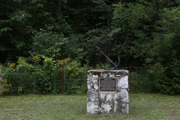
A monument marks the start of the Opeongo Line at Farrell's Landing, Ont. The plaque describes Horton township council's decision on May 26, 1851, to build a road to 'facilitate travel for early settlers to the interior.'Dave Chan/The Globe and Mail
All that’s left of Farrell’s Landing, where so many settlers began their journey into the Valley, is a strip of grass a few metres wide leading down to the Ottawa River, flanked by cottages and the Grandview Trailer Park, a collection of aging trailers used by summer residents. The park was owned by Terry Johnston in 1993 and is owned by him today, although at 72, he’d like to sell.
History buffs used to come by now and then to see the landing, “but not so much any more,” he says. Some cottagers want to buy the land, but the township is holding onto it for now. He hopes things stay that way. “It’s nice to have a little bit of history,” he says. But whether Mr. Johnston will be there to greet the next history buff that comes by – well, who knows?

Terry Johnston walks up the landing spot of the Opeongo Line from the Ottawa River at Farrell's Landing near Castleford, Ont.Dave Chan/The Globe and Mail
There are some decent farms between the river and the town of Renfrew, 12 km to the west, where you pick up the Opeongo Road, which morphs into Highway 132. To stay close to the path of the original Line, you need to get off the highway here and there and take local roads. You have left the more fertile lowlands stretching west from the Ottawa River and entered the Precambrian Shield, as you weave among the rocky Opeongo Hills.
Impressions: Twenty-five years ago, there were more farms. Today, there is more forest. Twenty-five years ago, you could still see split-rail fences and log barns the settlers had built with their own hands. Gone now, mostly, lost to the bush or carried off by someone in search of portable heritage. Twenty-five years ago, there were general stores in villages such as Dacre and the little churches along the Line still held services on Sunday. Both are now mostly closed. The villages aren’t really villages any more – just a few houses, some abandoned, some occupied by old people biding their time.
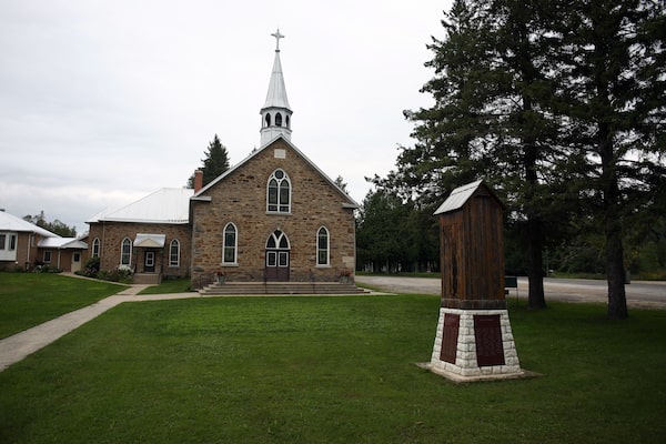
The Church of St. Patrick, established in 1869, still holds services today. 'The people are old, but they have a deep faith,' Sister Zita O’Grady says.Dave Chan/The Globe and Mail
The Upper Canadian government pushed roads into Central Ontario in the years before Confederation, hoping to expand the settled area and the population of the colony. The Ottawa and Opeongo Road, which became known as the Opeongo Line, was also intended to ferry troops between the Ottawa River and Georgian Bay, in the event the Americans invaded. (“Opeongo” is derived from the Algonguin opeauwingauk, which means “sandy narrows." The Ottawa Valley is their unceded land.)
The surveyors warned that the soil was rocky and poor, but the government was determined, and the wretched fleeing poverty and war in Europe didn’t know what they were getting themselves into. They would find land along the Line they thought they could farm, then walk to Mount St. Patrick to register their claim.
In that village, the Church of St. Patrick (established 1869) still holds services. Sister Zita O’Grady, who minds the place, estimates as many as 150 people gather for Sunday mass. “The people are old, but they have a deep faith,” she says.
Up the hill, Teresa Connaughan and Kitty Brunke are keeping each other company on a muggy summer’s afternoon. Ms. Connaughan has lived in the village all of her 72 years. They both speak with the soft Irish lilt that you still hear in some of the Ottawa Valley native-born.
How have things changed in this quiet place over the past 25 years? “Quieter still,” they reply in unison, and laugh.

Teresa Connaughan, 72, has lived in the village of Mount St. Patrick all her life.Dave Chan/The Globe and Mail
It's hard. Since the general store closed, even getting milk and eggs means a trip into Renfrew, 25 km each way. But Ms. Connaughan would never think of leaving. “No better place than the Mountain,” she says, with finality.
Forty kilometres to the west, on what is still called the Opeongo Road, Frances O’Brien sits in her kitchen. We talked 25 years ago, when she predicted the O’Brien farm “was going back to bush.” Today, at 94, “I’m not going very fast, now,” she smiles. But her son Gerard, who is 58, still keeps 50 head of beef cattle and the land cleared. In the winter, he works in the bush, “though the last couple of years has been very, very slow.”
His is one of the few farms left on this part of the Line. “A lot of our neighbours got out of farming,” he reports. When St. Joseph’s Church, which is just down the road, closed a few years ago, “that was the end of our community, in my opinion. You don’t see anyone any more, unless someone dies.”
Why does he keep at it? “Oh, I don’t know. Probably the history.” O’Briens have been farming in the Valley since the 1850s. He doesn’t want to give it up, although “it’s getting to the point it doesn’t make sense.”
A few kilometres to the west, the old radar station at Foymount has long been abandoned. It was part of NORAD’s Pinetree Line, set up to detect approaching Russian bombers, until it closed in 1974. The clothing company Black Water Designs employed up to 200 people there, 25 years ago. But owner Richard Gulland eventually sold the business and retired, and now it’s closed.
Down the road in Brudenell, there is little left of what was already mostly a ghost town in 1993. Back in the day, Brudenell was known as a “sin bucket,” with three hotels of various repute, a casino in a barn and even a track for horse racing. Today, a couple of houses look to be occupied, although no one answers the knock on the door. The rest are abandoned.
Derek Murray’s great-great-great grandparents settled in Brudenell in the 1860s and he wrote his PhD thesis on settlement patterns in the township. A historian who now teaches at the University of Victoria, he rejects the narrative that the story of the Opeongo Line is one of failure.
“It never resonated with me,” he says. Yes, people abandoned Brudenell and other places along the Line, “but they didn’t go far.” More substantial villages and towns to the north – Eganville, Wilno, Killaloe (where Mr. Murray, who is 35, grew up) and Barry’s Bay – carry on to this day, dependent mostly on tourism and forestry.
“This idea of failed settlement is something written by outsiders for outsiders,” he says.

The cemetery behind St. Patrick's church. The farmers who first built Ontario may have been a dour, blinkered lot bound by the prejudices of their day, but they paved the road for what was to come.Dave Chan/The Globe and Mail
The government gave up on the Opeongo Line somewhere beyond Barry’s Bay, about 180 km west of Farrell’s Landing. The soil was just no good. But the people didn’t give up. The subsistence farms and tiny villages along the Line clung to the Shield through wars and depression and modernity. Electricity didn’t arrive in some parts until well after the Second World War. It didn’t matter. People owned their land and their own souls. The husband farmed and worked in the bush, maybe the wife took a job in town. They made do. But every year, it became harder, and eventually the children said they wanted no part of it.
Meanwhile, Ontario continued its transformation into the hub of Greater Toronto and the ever-more-marginal spokes of the rural shires. Manufacturing, information technology and financial services have long since replaced a few head of cattle and working in the bush. The Philippines and India and China and Pakistan have replaced Britain and Ireland and Poland and Germany as the new Old Countries.
This is probably just as well. The stiff-necked farmers who broke the soil and established the farms that built the first Ontario were prudish, intolerant and largely without humour. The fights between Protestants and Catholics, the condescension toward those beneath you and resentment of those above, the casual racism, the suspicion of excellence, or even difference, the contempt for art – the settlers and many of their descendants were a dour, blinkered lot.
But they were hard workers, stubborn at worst but determined at best, faithful to their God and kin, righteous in their sense of right and wrong. Their values remain the bedrock of today’s vibrant, urban, diverse, fabulously polyglot province, the heartland of Canada, whether we like it or not. They made this place.
Walking up the steep hill on Newfoundout Road – one of the many settlement roads that ran off the Line up into the hills to farms that are now long gone – I realize I came to the Opeongo Line again to say goodbye. This part of Ontario’s culture – largely rural, often poor, with a straight line back to the original pioneers – has long been in decline. As the bush claims the last farms, the last houses in the villages are closed up, the schools consolidated and consolidated again, this heritage will disappear.
Mr. Murray is surely right that communities in the Upper Ottawa Valley will endure long into the future. But for the Opeongo Line itself, the outlook is bleak. The Township of Brudenell, Lyndoch and Raglan had 1,503 people in 2016, which was 155 fewer than five years before; Madawaska Valley Township lost 159 souls in that time; Bonnechere Valley Township lost 89. The Line runs through all three.
Soon, apart from artists and eccentrics in search of isolation and great natural beauty, there may be no one at all. Soon, there may be little more than records and histories and bush. And a poem, written years ago by Tom Devine of Renfrew, called On the Opeongo Line.
On the Opeongo Line I drove a span of bays
One Summer, once upon a time for Hoolihan and Hayes.
The road was rough; the hours long; the pay, scarcely a wage;
The stopping places, none too good; but work was then the rage.
… Now that the bays are dead and gone and grim old age is mine,
A Phantom team and teamster start from Renfrew, rain or shine –
Aye, dreaming I go teaming on the Opeongo Line.
 John Ibbitson