- Check the Environment Canada forecast for your area
- Driving this week? Stay safe with Globe Drive’s winter guide
Ontario: Winter is coming
Many residents in Southern Ontario will face considerable snowfall over the next couple of days.
A system moved into the province on Monday and hit parts of Southern Ontario. Environment Canada meteorologist Steve Knott says the snow will head east throughout the week.. Mr. Knott predicts the snow will continue until Wednesday morning, which complicates a week that is spring break for many Ontario schools:
For the remainder of the week we're going to stay quite a bit below normal as far as the temperatures go, which maybe some people are happy about when they're on spring break, but I suspect maybe not.
Fifteen to 25 centimetres of snow are expected in most areas, with up to 30 cm forecast for the Hamilton-Niagara corridor. The Ontario forecast remains cold for the rest of this week.
Extreme winter driving weather expected in our forcast today, be sure to have an emergency kit & patience #SnowMeansSlow #OntStorm ^ao pic.twitter.com/VgUVJKwjED
— HRPS Burlington (@HRPSBurl) March 13, 2017
Police have been urging drivers to be careful on the roads and air travellers are being urged to check the status of their flights before leaving home.

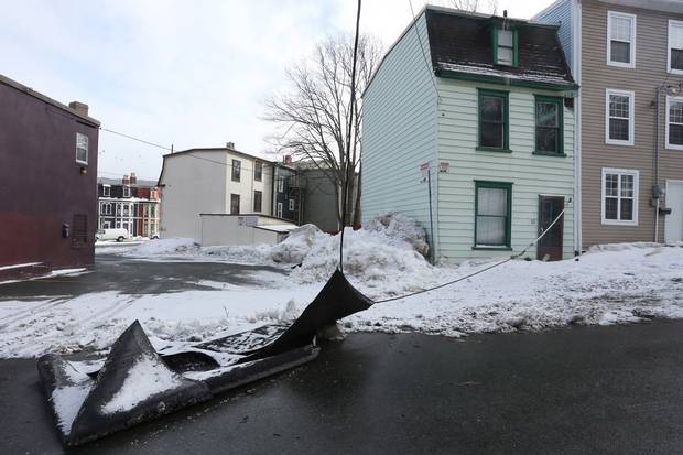
A St. John’s house shows the aftermath of the weekend’s storm on Monday morning.
PAUL DALY/THE CANADIAN PRESS
Atlantic Canada: Winter is coming back
After getting battered by cold gale-force winds over the weekend, Newfoundland is due for another blast of winter weather this week, Environment Canada predicts. An intense low-pressure system is expected to cross over the Maritime provinces midweek, bringing snow and strong winds across the region before hitting southwestern Newfoundland on Tuesday night. By Wednesday, that snow could turn into ice pellets or freezing rain.
On Monday, power crews were still working to restore electricity to about 5,000 customers after a massive weekend windstorm wreaked havoc in Newfoundland and Labrador. Newfoundland Power spokeswoman Michele Coughlan told The Canadian Press that the utility hopes to restore power for most of the remaining customers by the end of the day, adding that although the weather was still cold, weather conditions had stabilized for work crews who battled sustained and strong winds over the weekend:
We had 110 kilometre an hour sustained winds. For many of our crews who have been through many storms . . . they describe it as being worse than hurricane Igor [in 2010].
Ms. Coughlan said that 3,000 of the isolated outages are on the Avalon and Burin Peninsulas while another 2,000 are in St. John's and surrounding areas. She says at its height on Saturday the storm affected about 70,000 customers, downing power lines, cracking poles and breaking crossarms on lines in some areas.
The ongoing power outages also led to a water conservation order issued for all residents in St. John's, Mount Pearl, Paradise, Portugal Cove-St. Phillips and Conception Bay South. Technical issues at the Bay Bulls Big Pond water treatment facility were cited as the cause.
Meanwhile, Newfoundlanders were continuing to assess the damage caused by wind gusts of between 140 and 160 kilometres an hour .
Watch the fierce winds that caused damage in Newfoundland
Damage evident around St. John's included slate tiles that were blown into an alley 100 metres from a downtown church. Roofs were also partly off several houses and buildings and a home in nearby Torbay had its top floor blown off.
In St. John’s, the windy weather blew down structures on people’s properties …
PAUL DALY/THE CANADIAN PRESS
… and tore signs apart at local businesses.
PAUL DALY/THE CANADIAN PRESS
Many streetlights are disabled or missing.
Paul Daly/THE CANADIAN PRESS
How to shovel snow
If you've got a driveway or sidewalk to clear this week, here are some pointers on how to do it efficiently and without hurting yourself.

TRISH McALASTER/THE GLOBE AND MAIL
MORE FROM THE GLOBE AND MAIL

