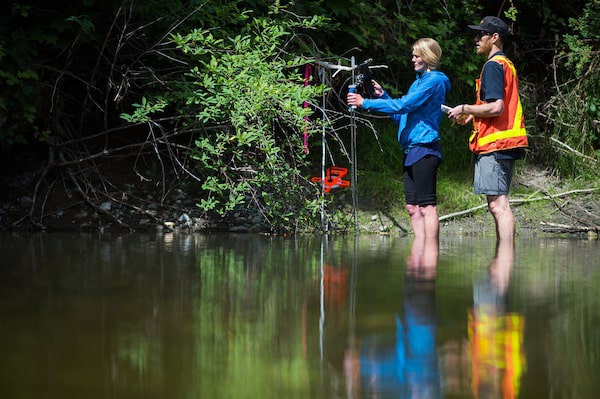
Water manager Matt MacDonald and and Sarah Hardy a senior authorizations technologist with B.C.'s Ministry of Forests, Lands and Natural Resources, check the water levels in the Chemainus River, which are unusually low this year.James MacDonald/The Globe and Mail
Matt MacDonald and Sarah Hardy sloshed through the Chemainus River this week weighed down by research gear. The sun was shining and swallows darted over gentle riffles of water, painting an idyllic scene. But the researchers’ task was too easy.
“Two weeks ago, I was up to my waist here,” Mr. MacDonald observed. Now, the water barely touched his knees. The technical team from the province’s water-management department was here to chart water pressure, depth and the rate of flow: Even without their FlowTracker equipment and atmospheric gauges, it was plain that the Chemainus is unseasonably low and lazy.
There are coho and steelhead fry in here, some trapped in isolated pools left behind as the water levels dropped. Typically, these young salmon and trout will spend the summer in the river before making their way to the ocean, but right now, their survival is in doubt.
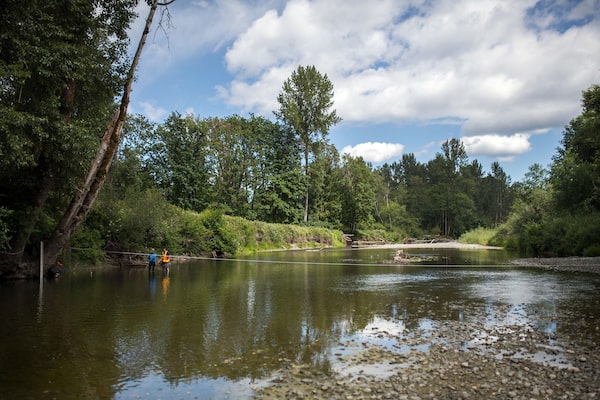
Across British Columbia, this spring has set the stage for drought. June is usually wet, but everywhere is dry, vast swaths of the province are very dry, and in some places, including the Chemainus River, the drought rating is extremely dry. Environment Canada has warned of more hot weather to come. For the farmers who tap into this river to irrigate their crops just steps away from where the technical team conducts their measurements, that is a worry. But this is not just a local concern.
Earlier this week, the House of Commons declared a climate emergency in Canada. In B.C., which has been hammered in recent years by record-breaking wildfires, droughts, flooding and a forest-destroying plague of pests, the provincial government isn’t ready to make that declaration.
The low water levels Ms. Hardy and Mr. MacDonald are seeing in the Chemainus are only one sign of the worsening risks B.C. faces from climate change. Drought makes forests more susceptible to wildfires, endangering people's lives and homes and causing health risks for those who breathe the smoke.James MacDonald/The Globe and Mail

B.C. drought levels
As of June 13
Fort Nelson
Fort St. John
Prince
Rupert
Fraser
Lake
Prince
George
Williams Lake
Kamloops
LEGEND
Kelowna
Dry
Vancouver
Very dry
Victoria
Extremely dry
MURAT YÜKSELIR / THE GLOBE AND MAIL, SOURCE:
GOVERNMENT OF B.C.

B.C. drought levels
As of June 13
Fort Nelson
Fort St. John
Prince
Rupert
Fraser
Lake
Prince
George
Williams Lake
LEGEND
Kamloops
Dry
Kelowna
Very dry
Vancouver
Extremely dry
Victoria
MURAT YÜKSELIR / THE GLOBE AND MAIL, SOURCE:
GOVERNMENT OF B.C.

B.C. drought levels
As of June 13
Fort Nelson
Fort St. John
Prince
Rupert
Prince
George
Fraser
Lake
Williams Lake
LEGEND
Kamloops
Dry
Kelowna
Very dry
Vancouver
Victoria
Extremely dry
MURAT YÜKSELIR / THE GLOBE AND MAIL, SOURCE: GOVERNMENT OF B.C.

Active wildfires in B.C.
As of June 21
Fort Nelson
Fort St. John
Fraser
Lake
Prince
Rupert
Prince
George
ACTIVE FIRES
Williams Lake
In hectares
Kamloops
120,000
Kelowna
Vancouver
Victoria
6,000
60
MURAT YÜKSELIR / THE GLOBE AND MAIL, SOURCE:
B.C. WILDFIRE SERVICE

Active wildfires in B.C.
As of June 21
Fort Nelson
Fort St. John
Fraser
Lake
Prince
Rupert
Prince
George
ACTIVE FIRES
Williams Lake
In hectares
120,000
Kamloops
Kelowna
Vancouver
Victoria
6,000
60
MURAT YÜKSELIR / THE GLOBE AND MAIL, SOURCE:
B.C. WILDFIRE SERVICE

Active wildfires in B.C.
As of June 21
Fort Nelson
Fort St. John
Prince
Rupert
Prince
George
Fraser
Lake
ACTIVE FIRES
In hectares
Williams Lake
120,000
Kamloops
Kelowna
Vancouver
6,000
Victoria
60
MURAT YÜKSELIR / THE GLOBE AND MAIL, SOURCE: B.C. WILDFIRE SERVICE

B.C. Smoky Skies Bulletins,
by weather forecast region
Number of issued advisories,
2017 – June 5, 2019
Fort Nelson
Fort St. John
Fraser
Lake
Prince
Rupert
Prince
George
LEGEND
0 - 20
Williams Lake
20 - 40
40 - 60
Kamloops
60 - 80
Kelowna
Over 80
Vancouver
No data
Victoria
*The Smoky Skies Bulletin is a public advisory to communicate the rapidly changing nature of wildfire smoke. It is issued when areas of the province are being affected or have reasonable potential to be affected by wildfire smoke within 24-48 hours.
MURAT YÜKSELIR / THE GLOBE AND MAIL, SOURCE:
GOVERNMENT OF B.C.; ENVIRONMENT AND CLIMATE
CHANGE CANADA

B.C. Smoky Skies Bulletins,
by weather forecast region
Number of issued advisories, 2017 – June 5, 2019
Fort Nelson
Fort St. John
Fraser
Lake
Prince
Rupert
Prince
George
LEGEND
0 - 20
Williams Lake
20 - 40
40 - 60
Kamloops
60 - 80
Kelowna
Over 80
Vancouver
No data
Victoria
*The Smoky Skies Bulletin is a public advisory to communicate the rapidly changing nature of wildfire smoke. It is issued when areas of the province are being affected or have reasonable potential to be affected by wildfire smoke within 24-48 hours.
MURAT YÜKSELIR / THE GLOBE AND MAIL, SOURCE: GOVERNMENT
OF B.C.; ENVIRONMENT AND CLIMATE CHANGE CANADA

B.C. Smoky Skies Bulletins, by weather forecast region
Number of issued advisories, 2017 – June 5, 2019
Fort Nelson
Fort St. John
Prince
Rupert
Prince
George
Fraser
Lake
LEGEND
0 - 20
Williams Lake
20 - 40
40 - 60
Kamloops
60 - 80
Kelowna
Over 80
Vancouver
No data
Victoria
*The Smoky Skies Bulletin is a public advisory to communicate the rapidly changing nature of wildfire smoke. It is issued when areas of the province are being affected or have reasonable potential to be affected by wildfire smoke within 24-48 hours.
MURAT YÜKSELIR / THE GLOBE AND MAIL, SOURCE: GOVERNMENT OF B.C.;
ENVIRONMENT AND CLIMATE CHANGE CANADA
Hazards to human health
The economic impact of a changing climate is readily apparent in B.C. as forestry-mill closings across the Interior this month mark the beginning of a major shift. The combination of the mountain pine beetle epidemic and the past two years of unprecedented wildfires have dramatically altered the amount of forestland that can be sustainably harvested in B.C.
Less obvious is the threat to human health.
“The impacts are enormous,” said Tom Kosatsky, the the BC Centre for Disease Control (BCCDC) environmental health lead.
Forest-fire smoke since the summer of 2017 has affected every community in B.C except the islands of Haida Gwaii. The pollution from wildfire smoke has led to 10,000 additional visits to the doctor for asthma treatment, according to the BCCDC.
Wildfire smoke is particularly a threat to people suffering from respiratory or cardiovascular disease; pregnant women; infants and young children; the elderly; the poor and the homeless. “It’s a classic air pollutant," Dr. Kosatsky said, "and sometimes it goes on for days, people being assaulted with Beijing-like air.”
The National Collaborating Centre for Environmental Health warns that growing wildfire risk in Canada threatens health over wide geographic areas.
Smoke exposure can have acute health effects, from increased reporting of respiratory and cardiac symptoms through to increased risk of death. Dr. Kosatsky said those smoky-skies advisories issued by the B.C. Ministry of Environment are not to be ignored. “We don’t want to stop people from being outdoors and physically active. But there are some times … that breathing that kind of air is bad for you."
Heat waves can kill. On June 12, new temperature records were set in 17 communities in B.C. It was short-lived heat wave, but sustained heat events can be deadly. Dozens of people have died in India’s most recent heat wave, with temperatures soaring to 50 C. But it doesn’t have to get that hot to be dangerous. Even changes in normal temperatures can put residents at risk. The BCCDC says B.C.’s coastal and northern communities are least prepared to adapt in sustained heat events. In 2009, the city of Vancouver saw a spike in deaths during a heat wave, prompting new plans to help the city adapt in the future.
The BCCDC warns that many other B.C. municipalities are still unprepared for extreme heat events. Dr. Kosatsky said cities can change their infrastructure – such as adding more green space because trees counteract the heat-retaining properties of concrete. In the midst of a heat wave, cities need to distribute water and offer large, indoor spaces for people to cool down.
B.C. is susceptible to changes in precipitation – either too much or too little. Thousands of residents around Grand Forks were evacuated in 2018 because of flooding. In 2017, floods and debris flow added to the unprecedented wildfires to force the province to look at a “new normal” in weather extremes. Health authorities warn drought or flood can bring waterborne disease, cause psychological harm and affect drinking water. Even without catastrophic events, the shifts between high and low flows in rivers can affect drinking water, particularly in small water-treatment systems.
The Centre for Disease Control has proposed mitigation for B.C. communities to help residents adapt to climate change. But Dr. Kosatsky says that’s just nibbling at the edges of the real problem: “We can prepare for these changes one by one, but then we need to smarten up and achieve our climate-change targets, move to a low carbon alternatives, to bend back the curve.”
The Holt River, which feeds into the Cowichan River, is unseasonably low this month.James MacDonald/The Globe and Mail
Mark Worthing of the Sierra Club of B.C. stands in the waters of the Cowichan. 'You shouldn't be able to see the bottom here,' he says, and yet he can.James MacDonald/The Globe and Mail
A climate emergency?
Mark Worthing slipped under the clear water in a favourite swimming hole this week, where Holt Creek feeds into the Cowichan River. The Cowichan is designated as a national Heritage River, famed for its trout fishing and packed, in summer, with visitors drifting down its gentle rapids in inflatable tubes.
Mr. Worthing, a Sierra Club BC campaign organizer, wants to draw attention to a disturbing development resulting from the low water flows in this watershed. “You shouldn’t be able to see the bottom here,” he says. But there it is.
The forest surrounding the river here is a rare pocket of old growth preserved within park boundaries, and its towering canopy acts to regulate the temperature of the river. But the snowpack has long since melted, the rains haven’t come and this spring has been hot. The Holt is just a trickle; the Cowichan is moving slowly.
Jonathan Boyd, a hydrologist with the B.C. River Forecast Centre, says the drought concerns across the province are due to a confluence of events: Since mid-January, B.C. has experienced a lower-than normal snowpack, unusually warm spring temperatures, precious little rain and record-breaking heat. “It’s been one of the fastest melts of the snowpack we have seen, so it puts us in a vulnerable situation for drought,” he says. “It’s earlier than we have ever seen it, and it’s moving into a dire situation.”
The Sierra Club BC is calling on the B.C. government to declare a forest and climate emergency – the group points to the logging practices in the Cowichan Valley as an example of how human disturbances are increasing the risk of unmanageable climate impact.
Jens Wieting, senior forest and climate campaigner with the Sierra Club, spent part of June travelling through the Cowichan watershed, documenting where logging clear-cuts have altered the landscape. Intact old-growth forests are mostly gone here, and the second-growth forests do not have the same capacity to hold water and protect streams. “We are moving into uncharted territory with climate change … we are still using forestry regulation based on assumptions that no longer work," Mr. Wieting says. “We have seen over-harvesting for decades and now, combined with serious environmental degradation, changes are needed. It’s painful but we need to protect communities in the long term so that we have clean air and clean water.”
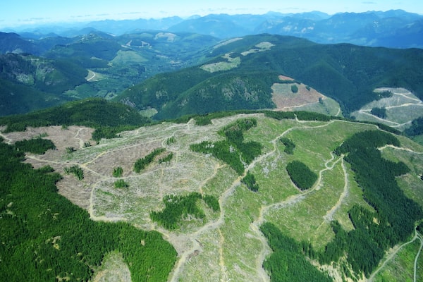
Aerial images taken by the Sierra Club's Jens Wieting in July, 2018, show swaths of clear-cut land near Cowichan Lake. The loss of water-bearing forests has left local streams unprotected.Jens Wieting/Sierra Club
The Premier’s plan
Last fall, the BC Greens called for the province to declare a climate emergency. Premier John Horgan’s NDP government balked then. This week, after the climate-emergency declaration in Ottawa, Mr. Horgan again demurred.
“The best course of action for government is to not declare there’s a problem, but to take steps to resolve the problem,” Mr. Horgan told a news conference on Tuesday. He chided the federal government for declaring a climate emergency just one day before it approved the construction of the Trans Mountain pipeline expansion, which Mr. Horgan said will accelerate the increase of greenhouse gas emissions in Canada.
“We believe that climate change and global warming are a significant threat to the well-being of the people of B.C. and, in fact, the world," the Premier said. His government is consulting with the public about forestry regulation, which could result in changes that will satisfy the Sierra Club. But in the meantime, the province is relying on its climate plan, Clean BC, to reduce fossil-fuel consumption. Mr. Horgan said that beats any formal acknowledgement of a crisis. “I believe the public would prefer to see action rather than statements and pronouncements from politicians and legislatures or city halls or in the town square, quite frankly."
 Justine Hunter