When it comes to the Gardiner Expressway, Toronto’s most pressing question is whether to tear it down or keep it up. What if we didn’t have a choice? Ahead of a decision on the east Gardiner, Oliver Moore travels to New York to see what’s happened in the decades since the city was forced to bring down most of the West Side Highway – and why that may now happen again in the Bronx
The coup de grace on New York’s deteriorating West Side Highway was performed, ironically, by a dump truck heading to do repairs.
The truck, carrying a 30-tonne load of asphalt, crashed through the deck near the now-trendy Meatpacking district in 1973. A big chunk of the neglected and run-down elevated highway was closed the next day and more than five kilometres was eventually pulled down.
Although there were concerns about congestion, the sky didn’t fall. Traffic was absorbed – a lot of it simply disappearing – and a park was eventually put in, driving up real-estate values and attracting families to the area. It proved that a city could do away with major infrastructure.
That example was followed by the collapse of the Embarcadero in San Francisco, which came down after being damaged in a 1989 earthquake, spurring a popular waterfront redevelopment.
“Once something does fall down and it’s closed anyway, you have a natural experiment: What happens if it is never opened again?” said Linda Bailey, executive director of the National Association of City Transportation Officials, a largely U.S. group that counts Toronto and Vancouver as members.. “That’s definitely a huge, frankly, advantage. Because it’s hard for politicians to make those kinds of calls.”
THE FINAL STRETCH
This month, city council is set to decide how the future of the eastern Gardiner – and Toronto’s waterfront – will look. This is a series examining the city's most contentious highway. Find more stories, videos and photos, past and present, all series long here or at tgam.ca/thegardiner.
>>Last update: Toronto chief planner at odds with mayor over eastern Gardiner removal
>>Alex Bozikovic on why the Gardiner must come down.
>>Marcus Gee on the optimistic early history of the Gardiner and its namesake: Frederick “Big Daddy” Gardiner
>>Elizabeth Church on how the Gardiner was the artery that connected her family.
>>Oliver Moore looks abroad to see how others have handled life with an elevated expressway.
>>Globe Debate: Dear Toronto: Tackling the Gardiner would be world-class
>>Before and after: An interactive look at the Gardiner's past and present
>>Video: The Gardiner in motion.
As Toronto wrestles with what to do with the elevated Gardiner East, moving toward a decision next week, advocates of removing it point out that scores of cities are now ditching or at least reconsidering the logic of having an urban expressway. The elevated ones – which carry large ongoing maintenance costs – are often at the top of the hit-list.
In cities as diverse as Houston and Paris, Seoul and Detroit, there’s a growing recognition that moving cars quickly is not the only or most important goal.
The same narrative is playing out again in New York, this time in the borough of the Bronx. Part of the Sheridan Expressway – a stretch of road that has many similarities with the Gardiner East in Toronto – is being touted as a candidate for conversion to a boulevard. New York Mayor Bill de Blasio is backing calls for an environmental study of the first steps of the project. And Bronx borough president Ruben Diaz Jr. has come out strongly in favour.
“We’re trying to rectify some of the major mistakes from the planners of yesteryear,” Mr. Diaz said.
The Globe and Mail went to New York to see how removing the West Side elevated highway allowed development to flourish over the decades, and how that success continues to be cited for possible future highway conversions like the Sheridan.
What about traffic?
Ground was broken on the elevated West Side Highway in 1929, starting a project that eventually ran right up the edge of Manhattan, alongside the Hudson River.
By the time the truck fell through in 1973, the negative impact of urban highways was becoming more broadly known in New York – where Jane Jacobs cut her teeth – and there was little appetite for an elevated replacement. Plans for a highway running through a tunnel buried under an expanded shoreline gained traction but were eventually scotched for environmental reasons.
News coverage from that era shows that concerns about traffic were voiced by advocates on every side of the issue. People who wanted another expressway said that closing the elevated section had caused vehicles to spill over onto local roads. Those opposed to a new expressway said building it would encourage more traffic and pollution.
During these years the elevated highway continued to deteriorate.
It was Sam Schwartz, as New York transportation commissioner in the 1980s, who eventually decided to pull down the still-standing portions of the highway, as far north as 57th street. The road was increasingly unsafe and too expensive to repair.
But a decade earlier he had played a less public but crucial role in the future of urban highways. Back then he had been an assistant engineer and the director of research and traffic studies for the city’s traffic department. It was up to him to figure out the impact on drivers caused by the closing of part of the highway immediately after the collapse.
Mr. Schwartz recalls comparing studies done in the autumns of 1973 and 1975. The results were surprising: A lot of the traffic just disappeared.
There was an uptick of traffic on the avenues toward the west of Manhattan. Transit also absorbed some, though this area is not well served by the subway and the 1970s-era system was decrepit and crime-ridden. But these increases couldn’t account for all the lost capacity. Tens of thousands of car trips evaporated.
The counterintuitive finding is most easily understood by thinking of traffic as a gas instead of a liquid. Research shows that traffic will expand to fill new space, a phenomenon dubbed induced demand. It will also shrink if the available space does, a pattern known as vanishing traffic.
Where does it go? People modify their behaviour. Some will switch to transit or other modes of travel, others will tweak when they drive. And discretionary trips, a surprisingly large portion of rush hour traffic, may be rethought.
The number of people coming into the city rose even though “there was this disappearing effect that we could not quite trace,” said Mr. Schwartz, who now runs the planning, traffic and transportation firm Sam Schwartz Engineering. “New York in ’75, we were going bankrupt.… We had crime that was surging, we had derailments on the trains that were every other week, and we still had more people coming in. Sometimes losing a highway does not mean fewer people. It might mean more people.”
What came next
At the time it collapsed, the West Side Highway ran through a sketchy area. Underneath the elevated highway was a seedy place one would be likely to visit only if catching a boat, working on the docks or looking for a prostitute.
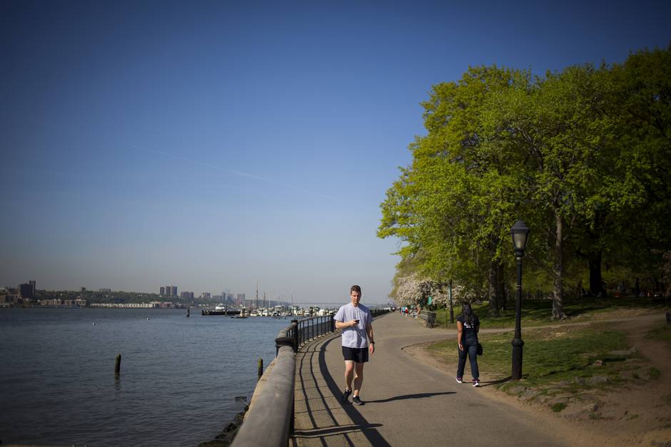
Today there is a broad street-level boulevard ranging from six to 10 lanes. It is effectively about the same size as two of New York’s avenues, running side by side and separated by a greened median. Traffic lights every few blocks give waterfront access to people on foot, though the roadway itself varies dramatically in the welcome it offers pedestrians.
The Javits Convention Centre’s back wall is a six-block facade only a brutalist could love. There’s a truck yard for the utility Con Edison, a repair shop for the Manhattan garbage department, and the Bayview Correctional Facility, a medium-security women’s prison.
But opposite the prison is the popular Chelsea Piers entertainment complex. And about a dozen blocks north is the hoarding for the massive Hudson Yards project, a $20-billion development that will include 16 skyscrapers and 12.7-million square feet of residential and commercial space. The project bills itself as “the new heart of New York.”
As one moves farther south, one reaches the West Chelsea neighbourhood, which now has some of the most expensive real estate in the city. The High Line, one of the most popular tourist attractions in the city, is visible between the buildings, and the Renzo Piano-designed new home for the Whitney Museum is a stone’s throw from where the truck went through the old elevated highway.

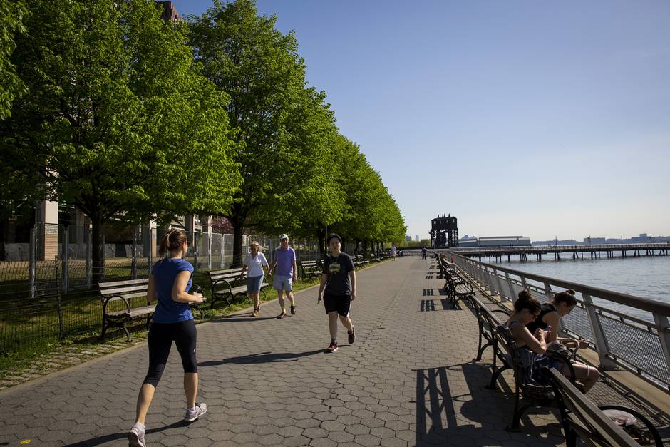
Running the whole way up, on the west side of the roadway, is the Hudson River Park. The second largest park in Manhattan, its existence was made possible by the demise of the elevated highway and then the death of the tunnelled successor that had been proposed.
At times the park is no wider than a bike path and pedestrian area. In other places it expands dramatically, offering space for children to play, couples to canoodle on the grass and tourists to watch the boat traffic on the Hudson River. Nearly 80 per cent of the park’s area is on the water, and visitors are encouraged to experience it with stand-up paddling, sailing and kayaks.
“In the warm weather you could find 100 people lined up,” said Madelyn Wils, CEO of the Hudson River Park Trust. “After work [the park is] busy all the time.”
The park has also brought broader change. Although Manhattan in general has boomed in the last few decades, Ms. Wils said the park has had a specific impact on the area nearby. She cited a $1.8-billion boost to the adjacent property market, and said the number of children under 18 has grown 400 per cent more there than in the rest of the city.
“When you live in a place like New York and you open a park, even across the road, people will come,” she said.

Safe passage
That simple act of crossing the street is at the heart of the dream of remaking the Sheridan Expressway in the Bronx.
In its current form, the highway is an effective barrier between two new parks along the Bronx River and an area where new development is expected to attract thousands of residents.
“Once upon a time this was dark and dormant and very [little] movement was going on,” said Mr. Diaz, the Bronx borough president. “Now we’re looking to have sort of like a mini city, right here in the Bronx. I’m excited about that.”
For now, the only practical ways to get from that area to the river are a dangerous intersection at the south end of the road or an elevated pedestrian bridge at the north end, an option that locals say makes them feel vulnerable.
A boulevard would turn the Sheridan and the road immediately beside it into a single roadway. The result would be narrower than the space taken up now by the two roads, freeing up land for other uses. And three pedestrian crossings would be installed, giving locals easy access to the park. There would also be other changes farther to the south, seeking to give truck traffic a more direct route into the 113-acre Hunts Point Produce Market, which serves the entire region.
The Sheridan is a mix of elevated, street-level and below-grade roadway. Although the stretch being considered for conversion to a boulevard is at street level, the highway is reminiscent of Toronto’s elevated Gardiner East: The Sheridan is lightly used, having been designed with the assumption of other highway building that didn’t happen. It is aging. It blocks the area from accessing the water. And converting it would open up a sizable chunk of land for development.


The Sheridan links the Cross-Bronx and Bruckner expressways, a few kilometres north of the spot where the fictional Sherman McCoy had the altercation – in Tom Wolfe’s 1987 novel The Bonfire of the Vanities – that sparked his downfall. The Bronx, back then a byword for crime and urban decay, is a different place now. It has cleaned up dramatically and, although the borough is statistically more dangerous than some other parts of New York, a visitor can walk its streets without expecting to encounter hassle.
This is still a long way from the gloss and wealth of Manhattan, though. Corner stores sell single rolls of toilet paper and advertise that their ATMs allow small-bill withdrawals. The area nearest the Sheridan is rundown, with cracked and dirty sidewalks. It’s grimily industrial, home to auto-body shops, self-storage businesses and a place to wash down street-sweeping machines.
But change is coming. Work is already underway on the first buildings of a large-scale development on the road beside the Sheridan. And on the other side are the new parks by the river.
Although these are most definitely urban parks, offering a view of the elevated No. 6 train, they’re also an oasis. You can see waterfowl paddling the waters. The docks act as kayak launches. The heat and traffic noise are quick to fade away.
“I think that Bronxites deserve amenities,” Mr. Diaz said, speaking alongside the Sheridan. “I think that we deserve a great boulevard in the way that the people who live in the west side of Manhattan get it.”

‘Why not here?’
In the era of postwar prosperity, many believed that success meant a home in the suburbs, reached by driving. Urban expressways were seen as unambiguously good. They were progress, modernity – a way to whoosh drivers from their suburban homes to jobs downtown, where it was assumed no one wanted to live anyway.
Toronto joined the highway boom, building infrastructure to serve what was presumed to be a permanent state of affairs. Now, a half-century later, the picture looks somewhat different.
Some suburbs are running out of developable land to exploit, threatening to bring higher property taxes that lessen the appeal of living there. Modern research into traffic has shown that cities can’t build their way out of congestion. Much of the future growth will have to be served by transit.
Meanwhile, urban downtowns are again being populated with residents. Some businesses are relocating back into the centre of cities. And the younger generation is showing much less interest in driving – or even getting a licence – than those who came before.
All of this means urban highways will have to justify their worth in a way they didn’t before. What’s good for drivers won’t necessarily be seen as being good for the city. And looming over the changing landscape is the ghost of the elevated West Side Highway – not so much an inspiration as simply proof that a highway doesn’t have to remain a permanent barrier. In New York it comes up repeatedly when locals discuss the Sheridan.
“I think what [it] shows is that things like this can be done, these are not just romantic concepts,” said Wilhelm Ronda, Bronx director of planning and development. “It’s something that’s realistic, that can be done. If it can be done elsewhere, why not here?”
