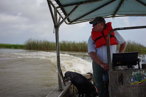
Ryan Lambert and his dog Logan survey new marsh growth in the Louisiana salt marshes, the result of Mississippi River sediment returning to the area.Photography by Leyland Cecco/The Globe and Mail
Ryan Lambert steers his aluminum skiff through the narrow channels of Louisiana’s salt marshes at the edge of the Gulf of Mexico. His hunting dog, Logan, peers over the side for birds, hidden among patches of roseau cane and windswept marsh grasses. Over more than four decades, Mr. Lambert has hunted and fished the waters. But the rapid changes to the landscape have left him deeply troubled as he scans the wetlands.
“We’ve already lost an area greater than the Grand Canyon,’ said Mr. Lambert, who runs a fishing lodge in the town of Buras.
In May, the Mississippi River and its tributaries were flooded across its vast floodplain, which covers more than a million square kilometres. Towns and farmland far upstream were flooded, costing farmers billions and keeping residents on edge.
While land loss and flooding are distinct crises, they are nonetheless linked to a single and profoundly important natural resource: the mighty Mississippi River. This heavily engineered freshwater highway, which generates billions in economic value, has increasingly punished many of the communities that rely on its waters.
Attempts to control the river’s natural flood cycles have had short-term benefits, but the long-term prospects are bleak for those along its lower banks, and made bleaker by the new challenges wrought by climate change. It’s unclear how much of the surrounding land can be saved, but, as relocation efforts get under way, the scenario serves as a cautionary tale about how much – or how little – we should tinker with nature. Other communities may yet learn from the mistakes made with the Mississippi.
For thousands of years, the waters of the river have flowed unimpeded from evergreen forests in Minnesota, along the agriculturally rich midwest states and into the south, where they pass through stands of cypress trees draped with wispy Spanish moss, eventually emptying into the Gulf of Mexico. Because of its slow and gently meandering route, it has become the most commercially important body of water in the United States. Each year, 175 million tons of goods move along its banks. By some estimates, the shipping traffic is worth in excess of US$500-billion. Farmers use it to get grains to China; oil and gas companies use it as simple route for moving crude oil to global markets.
To ensure the orderly movement of goods, the U.S. Army Corps of Engineers spent decades building a sprawling system of infrastructure along the Mississippi. The upper sections of the river and its two major tributaries are constrained through a series of locks and dams maintained by the Corps to ensure the river remains navigable. On the lower portions, from Illinois to Louisiana, the river is so large that no dams are needed. All of the river, including its southern section, is laced with dikes to help direct the channel and earthen levees to keep the river from pouring out onto the surrounding land.
But flooding, for all of its destruction, has an important role. Large rivers naturally carry millions of tons of sediment and are responsible for creating thousands of square kilometres of farmable land when floodwaters recede. The same cities that are protected by levees – such as New Orleans and Baton Rouge, along with the hundreds of towns and villages in the Mississippi Delta – exist because of countless sediment layers deposited by the river over thousands of years.
The fertile sediment of Southern Louisiana, like any delta region has a tendency to sink as it compacts, requiring constant replenishment to remain above the creeping Gulf of Mexico. But the levees, the engineering solution meant to prevent the river’s natural flood cycles, stop the Mississippi’s floodwaters from rebuilding land. As the Tragically Hip sang three decades ago, New Orleans is sinking.
As almost a direct result of these earthen mounds tracing the river, more than 5,000 square kilometres of coastline in Louisiana – which contains nearly half of America’s coastal wetlands – have been lost over the past 80 years. Areas where cows grazed only a decade ago are now beneath the ocean, Mr. Lambert said. “I’ve watched all the land around here completely disappear.”

The Mississippi River, near New Orleans. For decades, the U.S. Army Corps of Engineers tried to control the flow of the crucial trade route with large and expensive infrastructure projects throughout the river system.

In a natural flood cycle, sediment helps to replace land lost to subsidence and sea level rise, but the levees designed to control Mississippi floods also prevent the land from being rebuilt. Here, sediment is seen spilling from a broken river barrier.

slipping away
For decades, the coastline of Louisiana has slipped below the Gulf of Mexico. While the land loss is a combination of natural factors, including the subsidence of delta regions, both human interference in the river, as well as rising sea levels, have exacerbated the problem. Since the 1930s, Louisiana has lost nearly 5,000 square kilometres of land. If no action is taken, an estimated 10,300 square kilometres of coastline could be lost by 2050.
0
250
KM
Minn.
Wis.
Iowa
Neb.
Ill.
Ind.
Mo.
Kan.
Mississippi
River
Tenn.
Okla.
Miss.
Ala.
Texas
La.
DETAIL
LOUISIANA
MISS.
Baton
Rouge
Lake
Charles
Mississippi
River
New Orleans
Buras
0
100
KM
Gulf of Mexico
Land loss at 50 years, less optimistic scenario*
*2015 Rand Corp. analysis is based on model results for land
loss from four future without-action projections developed
for the 2012 Coastal Master Plan using 2010 as the base year
john sopinski/the globe and mail
source: qgis; rand corporation

slipping away
For decades, the coastline of Louisiana has slipped below the Gulf of Mexico. While the land loss is a combination of natural factors, including the subsidence of delta regions, both human interference in the river, as well as rising sea levels, have exacerbated the problem. Since the 1930s, Louisiana has lost nearly 5,000 square kilometres of land. If no action is taken, an estimated 10,300 square kilometres of coastline could be lost by 2050.
0
250
KM
Minn.
Wis.
Iowa
Neb.
Ill.
Ind.
Mo.
Kan.
Mississippi
River
Tenn.
Okla.
Miss.
Ala.
Texas
La.
DETAIL
LOUISIANA
MISS.
Baton
Rouge
Mississippi
River
Lake
Charles
New Orleans
Buras
0
100
KM
Gulf of Mexico
Land loss at 50 years, less optimistic scenario*
*2015 Rand Corp. analysis is based on model results for land
loss from four future without-action projections developed
for the 2012 Coastal Master Plan using 2010 as the base year
john sopinski/the globe and mail
source: qgis; rand corporation

slipping away
For decades, the coastline of Louisiana has slipped below the Gulf of Mexico. While the land loss is a combination of natural factors, including the subsidence of delta regions, both human interference in the river, as well as rising sea levels, have exacerbated the problem. Since the 1930s, Louisiana has lost nearly 5,000 square kilometres of land. If no action is taken, an estimated 10,300 square kilometres of coastline could be lost by 2050.
0
250
LOUISIANA
MISS.
Baton
Rouge
Mississippi
River
KM
Minn.
Lake
Charles
Wis.
10
New Orleans
Iowa
Ill.
Ind.
Mo.
Mississippi
River
Tenn.
Buras
Gulf of Mexico
Miss.
Ala.
Texas
La.
0
100
Land loss at 50 years,
less optimistic scenario*
KM
DETAIL
*2015 Rand Corp. analysis is based on model results for land loss from four future without-action projections developed for the 2012 Coastal Master Plan using 2010 as the base year
john sopinski/the globe and mail, source: qgis; rand corporation
After tracking the damage done in 2019, a handful of water experts agree that the Mississippi is growing larger and stronger, and it is only a matter of time before a large, cataclysmic disaster strikes.
In mid May, the Louisiana government announced ambitious plans to help move residents away from “high-risk” areas, an admission implied among the 1,500 pages of the government report that the situation is worsening.
“We have to be realistic about the current and future effects of coastal land loss and plan today to develop Louisiana’s next generation of communities,” Democratic Governor John Bel Edwards said in a statement after the release of the report.
Already, relocation efforts have begun. The Louisiana government will spend millions to move the Indigenous community of Biloxi-Chitimacha-Choctaw near New Orleans, whose territory on the Isle de Jean Charles has vanished by 98 per cent since 1955 because of land loss. And on a smaller scale, residents of Pecan Acres, a neighbourhood in Baton Rouge, are set to move to higher ground by 2021 – the result of a push to remove houses from “Flood City.”
With only levees to protect it, Mr. Lambert’s town of Buras, an outpost south of New Orleans, is in one of the highest-risk areas in the state. After the devastation wrought by Hurricane Katrina, and a recognition that the Gulf will continue to approach the land unabated, most of the residents have already left.
“What’s the use of saving something when no one’s here?” Mr. Lambert said.

This renewed marsh growth in Louisiana is the result of river sediment returning to Buras, where Mr. Lambert lives.
The state has allocated US$50-billion to fight coastal erosion, and already, a number of solutions are on the table. While experts agree that no single plan will save the coastline, a number of proposals taken together could have a substantive impact.
Some plans include developing cutting-edge – but costly – machinery to pump sediment from the river to areas where it is needed most, and creating human-made islands to keep the ocean water at bay.
Other residents – including Mr. Lambert – advocate breaking opening sections of the levees to divert river water back into areas that have been overtaken by salt water. There’s evidence that this approach can work: when Hurricane Camille broke through levees in 1969, one of those gaps was left open, allowing the river to resume the flows that had for years been halted. Over decades, the sediment-laden waters quickly rebuilt the archipelagos of vegetation, luring back wildlife that had long ago fled.
But Mr. Lambert, who has the ear of influential politicians in state government from his years of lobbying as a business owner, faces stiff opposition from oyster farmers, many of whom eke out meagre incomes from their work. They would face financial ruin if Mr. Lambert had his way – the freshwater from the river flooding, and subsequently destroying, their oyster farms.
And despite the optimism among those advocating for the leash around the river to be loosened, the current reality requires it be controlled as much as possible.
In late spring, a deluge of melted snow and heavy rains breached levees, inundated millions of hectares of farmland and flooded multiple towns. In the town of Cairo, Ill., just south of St. Louis, the river remained in a flood stage for more than 150 days in a row. July was no better, with a hurricane barrelling down on New Orleans and the river reaching dangerously high levels. Without levees, storm surges and widespread flooding would devastate the city, which sits below the river. A full-on disaster was avoided, largely the result of favourable weather patterns. But many believe it is only a matter of time.

Hydrology professor Yi Jun Xu worries it's too late to fix the damage done by the river and the engineering that's been done to it.
Yi Jun Xu, a professor of hydrology at Louisiana State University, has spent years scouring the river, studiously examining sediment buildup in different sections of the Mississippi.
With all its dams, he says, the river is like a pipe growing increasingly clogged at a rate faster than could ever hope to be cleared.
At the same time, Mr. Xu and his colleagues have watched with nervousness as the river continues to carry more and more water, a combination of runoff from farms upriver, increased precipitation and increased sedimentation. Their current prediction: The Mississippi River’s rate of discharge – the amount of water flowing along its banks – could increase by as much as 60 per cent by the end of the century.
“I can’t even imagine what that would mean,” he said, after spending an August morning collecting sediment samples in the field. “This makes me really, really concerned.”
Various scenarios he’s mapped out from his research, including the buildup of sediment causing the Mississippi to shift course and join a neighbouring river, the Atchafalaya, have a doomsday feel to them and their implications – the unabated encroachment of salt water and larger floods – are all catastrophic.
And the billions that will be spent on trying to save land, or even rebuild it, is “money thrown down a deep hole”, Mr. Xu said. Even if there were a silver bullet, he says, competing interests – energy companies, political parties, fisherman and residents – make decisive action impossible.
“This is a fight against nature,” he said. “And it’s really hard to fight against nature.”

Near New Orleans, a row of fishing cabins lies near quickly disappearing land.
For government officials – and those who remain in communities along the river – a difficult, if not impossible, dilemma lingers: maintain levees that stop floods, or take them down to allow the river to rebuild the quickly disappearing land.
The bitter irony threading the twin crises – of land loss and flooding – is the fact that the genesis of problems are human interference in the river. By endeavouring to tame the waterway, the Corps of Engineers have inadvertently created a slew of new problems.
“As our engineering and technologies improved over time, I think we’ve come to believe that we don’t exist within nature. Instead, we feel that in in many cases, we exist above nature,” said Matti Siemiatycki, director of the University of Toronto’s school of cities.
As unsalvageable as the situation in Louisiana looks, it nonetheless provides a useful set of instructions for other regions as governments worldwide look to adapt to increasingly erratic natural resources pushed to the brink by climate change.
“Climate change and the extremes and the speed at which these events now come on are really challenging our infrastructure and our ability to engineer solutions”, Mr. Siemiatycki said.
In communities along the banks of the Mississippi, cities have begun to rethink their relationship to the river. In Davenport, Iowa, officials have removed flood walls and levees, instead letting the river encroach further into the city. Any new construction has to be high elevation, letting the river run its course with reduced risk of flood damage.
Even in Canada, communities are revisiting their own natural resources. The Toronto Region and Conservation Authority has ambitious plans to bring the Don River back to its more natural state, before it was contorted by city planners, in a billion-dollar project that will minimize flood risk for nearly 240 hectares of land at the mouth of the river.
In Quebec, where record floods devastated numerous communities this spring, new provincial rules give affected homeowners $100,000 as compensation for a damaged house – or $200,000 if they choose to move away from the river.
With a forced rethinking of how humans interact with natural resources, a much more holistic approach with neighbouring waterways can be attained, Mr. Siemiatycki said.
While engineering will continue to have a key role in future planning, planners will need to think twice. Fights against nature aren’t winnable; the only question is how – and when – to finally co-operate.

A road snaking along land that is being overtaken by the Gulf of Mexico.
The author’s reporting was made possible partly through a fellowship from the Institute for Journalism and Natural Resources.
Our Morning Update and Evening Update newsletters are written by Globe editors, giving you a concise summary of the day’s most important headlines. Sign up today.